
Little Rock AFB Private
LRF · KLRF · Jacksonville, AR · Towered · Print kneeboard · Open on the map
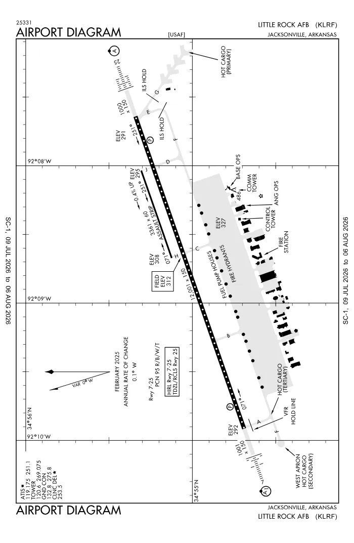 FAA airport diagramView full size ↓
 Nearby now
Loading…
Weather
METAR observed
Loading current weather…
TAF forecast
Loading forecast…
Sun & FAA night2026-09-18 · night begins 07:37 PM
| Event | Local (CDT) | UTC |
|---|---|---|
| Morning civil twilight Loggable night ends | 06:28 AM | 11:28Z |
| Sunrise | 06:53 AM | 11:53Z |
| Sunset | 07:11 PM | 00:11Z |
| Evening civil twilight Loggable night begins | 07:37 PM | 00:37Z |
Plan a flight from KLRF
Past 24 hours category · wind · ceiling · visibility trends
Loading station history…
Density altitude today projected curve · departure window · takeoff roll
Winds aloft NOAA forecast · 3,000 to 53,000 ft
Loading winds aloft…
Full reports: KLRF METAR decoded · KLRF TAF decoded
Advisories
NOTAMs · Loading NOTAMs…
Pilot reports · Loading PIREPs…
Airspace hazards · Checking SIGMETs and G-AIRMETs…
Temporary flight restrictions · Checking for TFRs…
Runways
RWY 25RIGHT trafficRP · charted
- Heading
- 252° mag · 251° true
- Dimensions
- 12,001 × 150 ft
- TPA
- 1,300 ft MSL (≈1,000 AGL) · standard
- Surface
- Concrete
- Lights
- 4-light PAPI (left) (3°) + ALSF2
- ILS
- ILS · CAT I · LOC 109.9 (TYV) · GS 3.00°
More details — RWY 25
- Threshold elev
- 291 ft
- Markings
- precision
- Threshold crossing height
- 55 ft
- TDZ elevation
- 301 ft
- End lights
- centerline, TDZ
Pattern side: FAA NASR · TPA standard 1,000 ft AGL (not charted) · layout: FAA runway-end coordinates
| Runway | Length | Your margin |
|---|---|---|
| 07/25 | 12,001 ft | |
| 071/251 | 3,354 ft |
Prefer one flat page? Full runway details for KLRF → · New to pattern entries? The 45° entry, explained → · Teaching here? Print the KLRF kneeboard →
Comms & NavAids
Communication frequencies
Before taxi
“Little Rock”Taxi & takeoff
“Little Rock”Departure & arrival
“Little Rock”ATC assigns the exact frequency (in your clearance or on handoff) — which one depends on your SID (departing) or STAR (arriving).
By procedure & sector (10 frequencies)
| Frequency | Used by |
|---|---|
| 138.6 | ANG OPS (HAWG OPS) |
| 225.45 | ANG OPS (HAWG OPS) |
| 239.8 | PMSV METRO |
| 251.1 | ATIS |
| 253.5 | CD/P |
| 269.075 | LCL/P |
| 275.8 | GND/P |
| 306.2 | APCH/P DEP/P |
| 349.4 | COMD POST |
| 372.2 | PTD |
Source: FAA NASR (current 28-day cycle).
Instrument landing systems
RWY 25
| Runway | ILS |
|---|---|
| RWY 25 | ILS · CAT I · LOC 109.9 (TYV) · GS 3.00° |
Source: FAA NASR (current 28-day cycle).
Nearby navigation aids
LRF 109.20 · LIT 115.10
| NavAid | Type | Freq · ch | Range | Radial / Dist magnetic |
|---|---|---|---|---|
| LRF · Jacksonville | TACAN | 109.20 · 29X | — | r094° / 0.6 NM |
| LIT · Little Rock | VORTAC | 115.10 · 98X | High | r003° / 6.5 NM |
Prefer one flat list? All KLRF frequencies →
Charts & procedures
Lowest minimums here: ILS with vertical guidance · VFR sectional →
Airport info
From the field
Do you run KLRF, or an FBO, flight school, or shop on it? Claim your listing to keep fuel, fees, hours, and services current.
Airport information
- ICAO / FAA LID
- KLRF / LRF
- Coordinates
- 34.9175, -92.1450
- Elevation
- 309 ft MSL
- Magnetic variation
- 1W
- Sectional chart
- MEMPHIS
- Airport use
- Private
- Control tower
- Yes
- Tower hours
- 24 hours
- Airspace
- Class D · CLASS D SVC 24 EXC CLSD HOL; OTHER TIMES CLASS E
- ARTCC
- MEMPHIS (ZME)
- Flight service (FSS)
- JONESBORO · 1-800-WX-BRIEF
- NOTAM facility
- LRF
- Attendance
- ALL ALL
- Beacon
- white-green (SS-SR)
- Segmented circle
- No
- Wind indicator
- yes
- Distance from city
- 1 SE
Activity & hazards NASR
- Parachute jumping — to 3,000 ft MSL · MON-FRI 0600-0200 AND OCNL WKNDS.
Night operations
- Airport lighting
- SS-SR
- Rotating beacon
- white-green · SS-SR
Runway lighting aids — 07: 4-light PAPI (left) + ALSF1 · 25: 4-light PAPI (left) + ALSF2.
FAA night windows (civil twilight, loggable night §1.1, currency §61.57) are under Sun & FAA night in the Weather section.
Services fuel · repairs · oxygen · attendance
- Parking
- hangars
- Other services
- Cargo
Ownership & management 2 contacts
Remarks FAA · 38 notes
General
- RSTD: PPR EXCP AIREVAC & ARMED FORCES COURIER.
- CAUTION: EXTV TURBO-PROP TRNG 1300-0600Z++ MON-FRI.
- RSTD: DEP ACFT REMAIN AT OR BLW 1400' TIL DEP END OF RWY. FTR ACFT UNABLE TO CTC DEP TIL AIRBORNE.
- CAUTION: PHASE II IN EFF APR-MAY & SEP-NOV.
- RSTD: NO PRACTICE APCH OR LDG DUR LCL FLYING.
- NS ABTMT - DEP HVY ACFT CLIMB RWY HDG TO 1500' AGL PRIOR TO TURNING ON CRS.
- CAUTION: SIGNIFICANT INCREASE IN BIRD ACT APR-MAY, SEP-NOV.
- CAUTION: DEER HAZ.
- RSTD: OFFL BUS ONLY 1700-2100Z++ WKD EXC AIREVAC AND ARMED FORCES CARRIER. OBTAIN PPR 72 HRS PRIOR TO ARRIVAL. CALL DSN 731-6123 OR C501-987-6123, PPR IS VALID +/- 30 MIN OF PROPOSED ETA.
- CAUTION: HI POTENTIAL FOR HYDROPLANING ON RWY 07-25 DUR PERIODS OF WET WX.
- CAUTION: NUMEROUS UNLGTD OBST LCTD PRIM SFC.
- CAUTION: NSTD RWY MRK- ASSAULT STRIP MRK (500' X 60') PAINTED ON RWY 25.
- MISC: ALL TRANSIENT ACFT CTC COMD POST 20 MIN PRIOR TO ARR.
- SERVICE-LGT: SFL INTS UNCTL MAY BE TURNED OFF O/R.
- JASU: 5(A/M 32A-86).
- FUEL: A-MIN POL CAPABILITY 2200-0600Z++ MON-FRI, EXP 2-4 HR DELAY DUR LCL FLYING.
- FLUID: SP PRESAIR LHOX LOX.
- OIL: O-133-148-156.
- SERVICE-TRAN ALERT: SVC AVBL 1300-0100Z++ MON-FRI, NO WEEKEND SUPPORT. AFTER HRS SUPPORT FOR HIGHER HQ MSNS ONLY.
- CAUTION: RWY 25 CNTRLN MARKINGS OBSCURED BY RUBBER DEPOSITS.
- SERVICE-LGT: NSTD INFRA-RED LGT CO-LCTD WITH RWY 07, 25 AND 249 EDGE LGT AND ONE NSTD INFRA-RED STROBE LCTD END OF RWY 07 AND 249 OVRN. INFRA-RED STROBE LCTD END OF RWY 25 CO-LCTD WITH RWY END LGT. THESE LGT ARE VIS ONLY THRU NGT NVD.
- RSTD: DEGRADED FIREFIGHTING CAPABILITY FOR B-2, C-5, VC-25, E-4, KC-10, MD-11, 747 AND 777 ACFT - COORD 48H PRIOR TO ARR FOR PPR AND SVC. CONFIRM RESCUE AND FIRE FIGHTING AVBL PRIOR LDG OR TKOF.
- MISC: ATC PERS IAW COOPERATIVE WX WATCH WILL ALERT WX PERS ON ANY UNREPORTED WX COND THAT COULD AFCT FLT SAFETY.
- MISC: LTD AIRCREW TRANSPORTATION WEEKENDS. TO ENSURE AIRCREW TRANSPORTATION AVBL UPON ARRIVAL, CTC AFLD MANAGEMENT AT LEAST 20 MIN PRIOR TO LDG.
- RSTD: USE OF ALERT APRON (X-MAS TREE) STUB 1 RQR PRIOR COORD WITH AFLD MANAGEMENT.
- CAUTION: AFLD LGT INTMT BTN SS/SR DUE TO LCL NGT VISION TRNG, NON-PARTICIPATING ACFT CTC TWR PRIOR TO ENTERING CLASS D AIRSPACE AND TO INCREASE INTS.
- SERVICE-LGT: RWY 25 ILS AND PAPI GS NOT COINCIDENTAL.
- RSTD: B52 ACFT LDG PROH.
- MISC: NO COMSEC AVBL FOR TRAN ISSUE. NO CLASSIFIED MATERIAL STOR AT AM OPS, STOR AVBL AT COMD POST.
- MISC: ARFF-CAT 3, WITH 14 PERS, 4880--5000 GAL OF CAPABILITY, CTC AMOP 731-6123 FOR UPDATED ARFF STATUS.
- MISC: AN/FMQ-19 AUTOMATED OBSERVATION SYS IN USE; AUGMENTED BY HUMAN OBSN WHEN NEC DUR AFLD HRS.
- MISC: AERODROME FOR NVG OPS TRAN ACFT SHOULD RCV BRIEFING FR 19 OSS TACTICS AT DNS 731-7013 OR 19OSS.OSKTACTICS@US.AF.MIL.
- FOR CD WHEN UNA VIA FREQ CTC LITTLE ROCK APCH 501-379-2908 OR LITTLE ROCK ATCT 501-379-2911.
- CAUTION: 3 FT TALL FIRE HYDRANTS LCTD N OF TWY F 100 FT FROM CNTRLN.
- CSTMS/AG/IMG: CTC SECURITY FORCES C501-987-3221 MIN 24 HR PN.
- RSTD: NO FIGHTER TYPE ACFT PPRS 1500-1600Z++ AND 1800-2000Z++.
- RSTD: TRAN AIRCREWS ARE ADVISED TO CARRY CREW ORDERS TO AVOID POTENTIAL DELAYS.
Attendance
- ARPT NMLY CLSD FED HOL FM 0400Z++ OR LAST LAND, THRU 1300Z++ SUCCEEDING DAY.
Embed KLRF weather on your site free widget for schools, clubs & FBOs
Live METAR, flight category, and favored runway for KLRF — paste this into your website's HTML. It updates automatically and stays free.
More widgets — crosswind, E6B, density altitude — on the embed page.
Nearby airports
Loading nearby conditions…
Also nearby: 79AR Franke Field (private) (6 NM) · 4AR2 Red Oak (private) (7 NM) · 4AR1 Shurley Field (private) (8 NM) · 6AR0 Cypress Creek Airpark (private) (9 NM) · KRBM Robinson AAF (Camp Robinson) (private) (9 NM)
About KLRF
Little Rock AFB (LRF · KLRF) is an airport in Jacksonville, AR, at 309 ft MSL. It has 2 runways, the longest 12,001 ft, with a control tower. This page shows live METAR/TAF weather, runway crosswinds, frequencies, navaids, and FAA charts for KLRF, refreshed from the Aviation Weather Center and FAA NASR.
Does KLRF have a control tower?
Yes. Little Rock AFB has an operating FAA control tower. See the Comms & NavAids section for tower and ground frequencies.
What is the longest runway at KLRF?
Little Rock AFB has 2 runways; the longest is 12,001 ft. See the Runways section for headings, surface, and lighting.
Where is KLRF?
Little Rock AFB is in Jacksonville, AR, at an elevation of 309 ft MSL. Coordinates: 34.9175, -92.1450.
More about KLRF
Weather is live from the Aviation Weather Center; airport facility data is from the FAA NASR (28-day cycle). For planning and education only; always verify against official sources. Open KLRF in a full tool: METAR/TAF decoder, crosswind calculator, sun & night times, or the density altitude calculator. Planning from here? Find the nearest airport with fuel or an approach, or check whether an IFR alternate is required.
Something here wrong or out of date? Report a data problem.