
Key West NAS (Boca Chica Field) Private
NQX · KNQX · Key West, FL · Towered · Print kneeboard · Open on the map
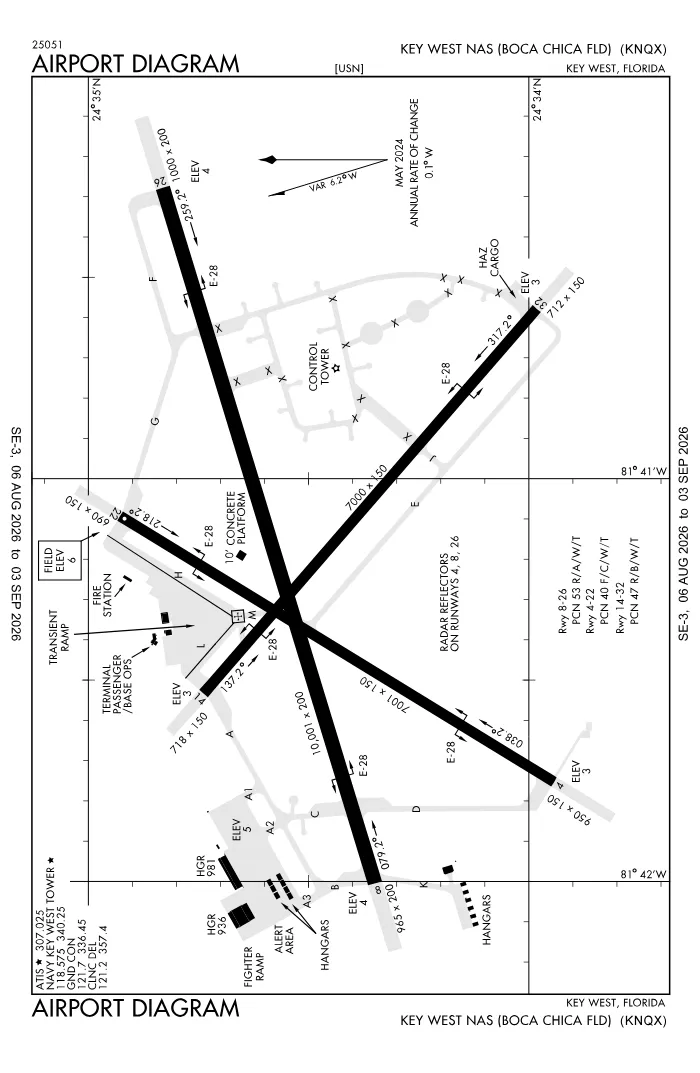 FAA airport diagramView full size ↓
 Nearby now
Loading…
Weather
METAR observed
Loading current weather…
TAF forecast
Loading forecast…
Sun & FAA night2026-09-18 · night begins 07:50 PM
| Event | Local (EDT) | UTC |
|---|---|---|
| Morning civil twilight Loggable night ends | 06:51 AM | 10:51Z |
| Sunrise | 07:14 AM | 11:14Z |
| Sunset | 07:28 PM | 23:28Z |
| Evening civil twilight Loggable night begins | 07:50 PM | 23:50Z |
Plan a flight from KNQX
Past 24 hours category · wind · ceiling · visibility trends
Loading station history…
Density altitude today projected curve · departure window · takeoff roll
Winds aloft NOAA forecast · 3,000 to 53,000 ft
Loading winds aloft…
Full reports: KNQX METAR decoded · KNQX TAF decoded
Advisories
NOTAMs · Loading NOTAMs…
Pilot reports · Loading PIREPs…
Airspace hazards · Checking SIGMETs and G-AIRMETs…
Temporary flight restrictions · Checking for TFRs…
Runways
RWY 14LEFT traffic
- Heading
- 137° mag · 131° true
- Dimensions
- 7,000 × 150 ft
- TPA
- 1,000 ft MSL (≈1,000 AGL) · standard
- Surface
- PEM
- Lights
- 4-light PAPI (right) (3°)
More details — RWY 14
- Threshold elev
- 3 ft
- Markings
- nonprecision
- Threshold crossing height
- 45 ft
- TDZ elevation
- 4 ft
- Arresting gear
- E28
Pattern side: FAA NASR · TPA standard 1,000 ft AGL (not charted) · layout: FAA runway-end coordinates
| Runway | Length | Your margin |
|---|---|---|
| 08/26 | 10,001 ft | |
| 04/22 | 7,001 ft | |
| 14/32 | 7,000 ft |
Prefer one flat page? Full runway details for KNQX → · New to pattern entries? The 45° entry, explained → · Teaching here? Print the KNQX kneeboard →
Comms & NavAids
Communication frequencies
Before taxi
“Navy Key West”Taxi & takeoff
“Navy Key West”Departure & arrival
“Navy Key West”Also
ATC assigns the exact frequency (in your clearance or on handoff) — which one depends on your SID (departing) or STAR (arriving).
By procedure & sector (12 frequencies)
| Frequency | Used by |
|---|---|
| 243.0 | EMERG |
| 289.85 | APCH/S DEP/S |
| 305.95 | LCL/P |
| 306.9 | KEY WEST RCAG (LOW/HIGH) |
| 307.025 | ATIS |
| 313.7 | APCH/P DEP/P |
| 336.45 | GND/P |
| 338.15 | BASE OPS |
| 340.25 | LCL/P |
| 343.5 | PMSV METRO |
| 357.4 | CD/P |
| 361.25 | LCL/S |
Source: FAA NASR (current 28-day cycle).
Nearby navigation aids
NQX 113.10 · EYW 113.50
| NavAid | Type | Freq · ch | Range | Radial / Dist magnetic |
|---|---|---|---|---|
| NQX · Key West | TACAN | 113.10 · 78X | — | r239° / 0.4 NM |
| EYW · Key West | VORTAC | 113.50 · 82X | High | r095° / 6.1 NM |
Prefer one flat list? All KNQX frequencies →
Charts & procedures
Lowest minimums here: RNAV (GPS) with vertical guidance · VFR sectional →
Airport info
From the field
Do you run KNQX, or an FBO, flight school, or shop on it? Claim your listing to keep fuel, fees, hours, and services current.
Airport information
- ICAO / FAA LID
- KNQX / NQX
- Coordinates
- 24.5746, -81.6866
- Elevation
- 6 ft MSL
- Magnetic variation
- 6W
- Sectional chart
- MIAMI
- Airport use
- Private
- Control tower
- Yes
- Tower hours
- 1200-0300Z++, OTHER TIMES BY NOTAM.
- Airspace
- Class D · CLASS D SVC 1200-0300Z++, OTHER TIMES BY NOTAM; OTHER TIMES CLASS G
- Weather station
- ASOS · 307.025
- ARTCC
- MIAMI (ZMA)
- Flight service (FSS)
- MIAMI · 1-800-WX-BRIEF
- NOTAM facility
- MIA
- Attendance
- ALL 1200-0300Z
- Beacon
- S-white-green (SS-SR)
- Segmented circle
- No
- Activated
- 1944/02
- Distance from city
- 4 E
Night operations
- Airport lighting
- SEE RMK
- Rotating beacon
- S-white-green · SS-SR
Runway lighting aids — 08: 4-light PAPI (left) + ALSF1 · 26: 4-light PAPI (left) · 04: 4-light PAPI (left) · 22: 4-light PAPI (left) · 14: 4-light PAPI (right) · 32: 4-light PAPI (left).
FAA night windows (civil twilight, loggable night §1.1, currency §61.57) are under Sun & FAA night in the Weather section.
Services fuel · repairs · oxygen · attendance
- Fuel available
- Jet (JP-5)
- Bottled oxygen
- NONE
- Bulk oxygen
- NONE
- Airframe service
- NONE
- Powerplant service
- NONE
Ownership & management 2 contacts
Remarks FAA · 21 notes
General
- A-GEAR: ALL E-28(B) SHORT FLD A-G IN RAISED POSN. EXC SHORT FLD A-G DUTY RWY DERIGGED.
- JASU: (NC-10) (MSU-200)
- FLUID: SP
- OIL: -O-128-156
- RSTD: UNLGTD RAMP PARL TO TWY L.
- TFC PAT: REDUCED RWY SEPARATION STD IN EFF USN/USMC ACFT.
- CSTMS/AG/IMG: AVLB 1200-2000Z++ MON - SAT, WITH PRIOR COORDINATION. ACFT REQ INSPECTIONS MUST ANNOTATE ON PPR AND NOTIFY NAVY APP WHEN IN RDO CTC WITH UPDATED ETA AND REQUEST CSTMS COORDINATION, FAILURE MAY CAUSE UNDUE DELAYS WITH CSTMS LIMITED RESOURCES.
- RSTD: PPR CTC AIR TERMINAL DSN 483-2769/2779, 305-293-2769/2779, FAX DSN 483-2355, C305-293-2355.
- CAUTION: UNLGT RAMP PARL TO TWY I; R2916 TETHERED AEROSTAT RADAR SYSTEM OPS CONT TO 14000; KEY WEST NAS & KEY WEST INTL HAVE ADJ CLASS D; CIVIL TFC SW & NW SECTS KEY WEST NAS CLASS D; BIRD HAZ; UNMRK/UNLGT TWY OBSTN.
- HAZARDOUS CARGO, TRANSIENT RAMP, AND FIGHTER RAMP LABELS.
- HOT CARGO PAD UNLIT; DAY USE ONLY.
- RSTD: PPR IS VALID FOR +/- 1 HR OF PROPOSED ETA. IF OUTSIDE OF ETA SLOT, CTC AIR TRML TO UPDATE PPR.
- MISC: FIGHTER ACFT OPS DLY M-SA 0800-1700. TRAN ACFT PRAC APCH NOT TO INTERFERE BASIS; PPR FOR COPTER LDG TRUMBO PT - CTC BASE OPS 15 MIN PRIOR TO ETA.
- SAR ONLY AVBL ON SAT-SUN WITH PRIOR CDN AND SKED ASP BY FRI PRIOR TO 1300Z++.
- TRAN ALERT: EXP SVC DELAYS; NO PRIORITY BASIS; LTD MAINT 1200-2100Z++ MON-FRI; TRANS ACFT RQRG FUEL PRVD QLFYD PSNL; FLEET SVC, POTABLE WATER & BASE TRNSPN NA; CLSD FED HOL.
- RSTD: CIV ACFT LDG PMT INFO - AMGR 305-293-2250; 305-293-2779.
- CAUTION: RWY 04/22, 7 FT OBST 87 FT WEST OF CNTRLN. FLOLS. 758 FT FM APCH END RWY 04, DER RWY 22. ONLY C-130 (WINGSPAN 32 FT) TYPE ACFT OR SMLR MAY OPR FOR LDG AND TKOF. ALL ACFT MAY TAXI DOWN RWY 22 TIL THE DER A-G.
- MISC: EV THU ALL APCHS PRIOR TO 1030L WILL BE IAW IFR PROCS.
Lighting
- AVBL DURG OPS HRS.
Fuel
- AVBL 1100-0400Z++MON-SAT, SUN 1400-0000Z++.
Attendance
- OT BY NOTAM; CTC ATC, C305-293-2770. FOR AIR SERVICES OR PPRS CONTACT C305-293-2779.
Embed KNQX weather on your site free widget for schools, clubs & FBOs
Live METAR, flight category, and favored runway for KNQX — paste this into your website's HTML. It updates automatically and stays free.
More widgets — crosswind, E6B, density altitude — on the embed page.
Nearby airports
Loading nearby conditions…
Also nearby: 7FA1 Sugar Loaf Shores (private) (7 NM) · FD51 Summerland Key Cove (private) (14 NM) · FA81 Tavernaero Park (private) (68 NM) · X01 Everglades Airpark (78 NM)
About KNQX
Key West NAS (Boca Chica Field) (NQX · KNQX) is an airport in Key West, FL, at 6 ft MSL. It has 3 runways, the longest 10,001 ft, with a control tower. This page shows live METAR/TAF weather, runway crosswinds, frequencies, navaids, and FAA charts for KNQX, refreshed from the Aviation Weather Center and FAA NASR.
Does KNQX have a control tower?
Yes. Key West NAS (Boca Chica Field) has an operating FAA control tower. See the Comms & NavAids section for tower and ground frequencies.
What is the longest runway at KNQX?
Key West NAS (Boca Chica Field) has 3 runways; the longest is 10,001 ft. See the Runways section for headings, surface, and lighting.
Where is KNQX?
Key West NAS (Boca Chica Field) is in Key West, FL, at an elevation of 6 ft MSL. Coordinates: 24.5746, -81.6866.
More about KNQX
Weather is live from the Aviation Weather Center; airport facility data is from the FAA NASR (28-day cycle). For planning and education only; always verify against official sources. Open KNQX in a full tool: METAR/TAF decoder, crosswind calculator, sun & night times, or the density altitude calculator. Planning from here? Find the nearest airport with fuel or an approach, or check whether an IFR alternate is required.
Something here wrong or out of date? Report a data problem.