
March ARB
RIV · KRIV · Riverside, CA · Towered · Print kneeboard · Open on the map
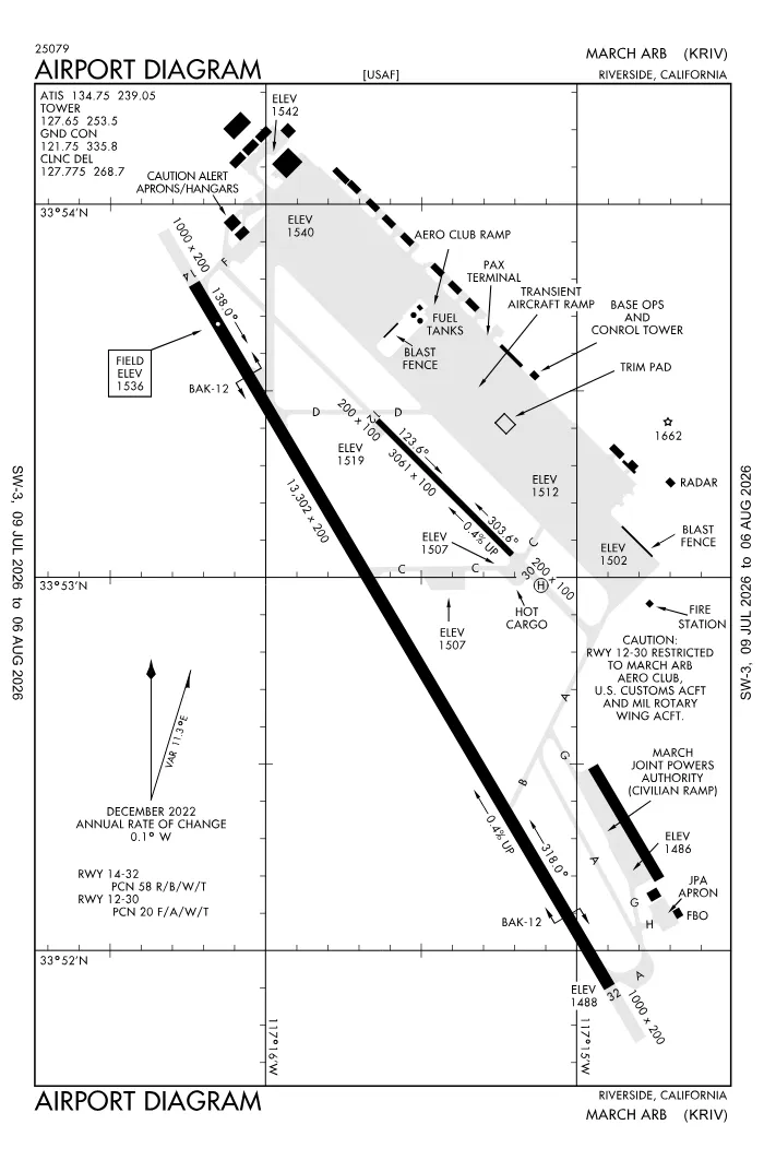 FAA airport diagramView full size ↓
 Nearby now
Loading…
Weather
METAR observed
Loading current weather…
TAF forecast
Loading forecast…
Sun & FAA night2026-09-18 · night begins 07:17 PM
| Event | Local (PDT) | UTC |
|---|---|---|
| Morning civil twilight Loggable night ends | 06:09 AM | 13:09Z |
| Sunrise | 06:34 AM | 13:34Z |
| Sunset | 06:52 PM | 01:52Z |
| Evening civil twilight Loggable night begins | 07:17 PM | 02:17Z |
Plan a flight from KRIV
Past 24 hours category · wind · ceiling · visibility trends
Loading station history…
Density altitude today projected curve · departure window · takeoff roll
Winds aloft NOAA forecast · 3,000 to 53,000 ft
Loading winds aloft…
Full reports: KRIV METAR decoded · KRIV TAF decoded
Advisories
NOTAMs · Loading NOTAMs…
Pilot reports · Loading PIREPs…
Airspace hazards · Checking SIGMETs and G-AIRMETs…
Temporary flight restrictions · Checking for TFRs…
Runways
RWY 12LEFT traffic
- Heading
- 121° mag · 135° true
- Dimensions
- 3,061 × 100 ft
- TPA
- 2,500 ft MSL (≈1,000 AGL) · standard
- Surface
- Asphalt
More details — RWY 12
- Threshold elev
- 1,519 ft
- TDZ elevation
- 1,519 ft
Pattern side: FAA NASR · TPA standard 1,000 ft AGL (not charted) · layout: FAA runway-end coordinates
| Runway | Length | Your margin |
|---|---|---|
| 14/32 | 13,302 ft | |
| 12/30 | 3,061 ft |
Prefer one flat page? Full runway details for KRIV → · New to pattern entries? The 45° entry, explained → · Teaching here? Print the KRIV kneeboard →
Comms & NavAids
Communication frequencies
Before taxi
“March”Taxi & takeoff
“March”Departure & arrival
“March”Also
ATC assigns the exact frequency (in your clearance or on handoff) — which one depends on your SID (departing) or STAR (arriving).
By procedure & sector (16 frequencies)
| Frequency | Used by |
|---|---|
| 119.25 | CLASS C |
| 133.5 | CLASS C |
| 138.45 | COMD POST |
| 239.05 | ATIS |
| 239.8 | PMSV METRO |
| 243.0 | EMERG |
| 252.1 | AFRC OPS · OPS (452 OG) |
| 253.5 | LCL/P |
| 270.275 | APCH/S DEP/S · CLASS C |
| 278.3 | APCH/P DEP/P |
| 306.975 | APCH/P DEP/P · CLASS C |
| 311.0 | RAINCROSS |
| 321.0 | RAINCROSS |
| 335.8 | CD/P · GND/P |
| 349.4 | RAINCROSS |
| 372.2 | PTD |
Source: FAA NASR (current 28-day cycle).
Instrument landing systems
RWY 32
| Runway | ILS |
|---|---|
| RWY 32 | ILS · CAT I · LOC 110.1 (RIV) · GS 3.00° |
Source: FAA NASR (current 28-day cycle).
Nearby navigation aids
RIV 113.00 · HDF 112.05 · RAL 108.60 · +4
| NavAid | Type | Freq · ch | Range | Radial / Dist magnetic |
|---|---|---|---|---|
| RIV · March | TACAN | 113.00 · 77X | — | r139° / 1.7 NM |
| HDF · Homeland | VOR | 112.05 | Low | r316° / 7.3 NM |
| RAL · Riverside | VOR | 108.60 | Low | r101° / 10.5 NM |
| PDZ · Paradise | VORTAC | 112.20 · 59X | High | r084° / 13.7 NM |
| ELB · El Toro | VOR/DME | 117.20 · 119X | Low | r048° / 26.6 NM |
| POM · Pomona | VORTAC | 110.40 · 41X | Low | r099° / 28.8 NM |
| NFG · Camp Pendleton | TACAN | 111.80 · 55X | — | r357° / 36.9 NM |
Prefer one flat list? All KRIV frequencies →
Charts & procedures
Lowest minimums here: ILS with vertical guidance · VFR sectional →
Airport info
From the field
Do you run KRIV, or an FBO, flight school, or shop on it? Claim your listing to keep fuel, fees, hours, and services current.
Airport information
- ICAO / FAA LID
- KRIV / RIV
- Coordinates
- 33.8819, -117.2590
- Elevation
- 1,536 ft MSL
- Magnetic variation
- 14E
- Sectional chart
- LOS ANGELES
- Airport use
- Public
- Control tower
- Yes
- Tower hours
- 24 hours
- Airspace
- Class C · CLASS C SVC MON-FRI 1500-0700Z++, SAT-SUN 1500-0200Z++, CLSD HOL; OTHER TIMES CLASS D
- ARTCC
- LOS ANGELES (ZLA)
- Flight service (FSS)
- RIVERSIDE · 1-800-WX-BRIEF
- NOTAM facility
- RIV
- Attendance
- ALL 0700-2300
- Beacon
- white-green (SS-SR)
- Segmented circle
- No
- Customs / AOE
- Yes
- Access
- Joint civil-military use
- Activated
- 1941/05
- Distance from city
- 6 SE
Night operations
- Rotating beacon
- white-green · SS-SR
Runway lighting aids — 14: 4-light PAPI (left) · 32: 4-light PAPI (left) + ALSF1.
FAA night windows (civil twilight, loggable night §1.1, currency §61.57) are under Sun & FAA night in the Weather section.
Services fuel · repairs · oxygen · attendance
- Fuel available
- 100LL, Jet A, A++
- Bottled oxygen
- HIGH/LOW
- Bulk oxygen
- HIGH/LOW
- Airframe service
- MAJOR
- Powerplant service
- MAJOR
- Other services
- Cargo, Charter
Ownership & management 2 contacts
Remarks FAA · 24 notes
General
- CAUTION: NSTD RWY MRK-LANDING ZONE (LZ) MARK (3500X90 PAINTED ON RWY 32 FOR BASE ASGN C17 ACFT ONLY).
- CAUTION: EXTV GLIDER, SKYDIVING, BALLOONIST AND ULTRALIGHT ACT AT PERRIS ARPT, 7 NM S OF MARCH.
- CAUTION: HEAVY MILITARY FLIGHT TRAINING.
- JOINT USE AIRPORT - OWNED AND OPERATED BY US AIR FORCE/ NO CIVIL TOUCH AND GO OPS OR MANEUVERS.
- AIRFIELD USE AGREEMENT WITH CIVIL ARPT AUTH (MARCH INLAND PORT ARPT AUTH) MILITARY, CIVIL COMMERCIAL AND GENERAL AVIATION(GA) USES.
- GA OPS - PPR AND/OR LANDING PERMIT NOT REQ FOR USE OF CIVIL APRON AND RAMPS/FBO INF. -FREEMAN HOLDINGS 951-247-2111 / FREQS 130.075.
- RY 12/30 CLSD TO PUBLIC DUE TO MUNITIONS AND EXPLOSIVES OPS IN CLOSE PROXIMITY OF RY 12/30 PER UFC & DOD REGULATIONS.
- TRANSPORTATION LIMITED, PRIOR COORDINATION REQUIRED, CTC DSN 447-7787 WKND.
- TSNT ACFT NO PRACTICE APCH 2100-0700.
- GEN AVN OPS PMTD DUR FBO BUS HRS. FBO BUS HRS 1400-0600Z++ MON-FRI, OPEN SAT-SUN (IF REQ PRIOR TO CLOSE OF BUS FRI) AND WILL HONOR MEDICAL REQ MADE AT ANY TIME, CALL 951-247-2111.
- USE EXTREME CAUTION FOR EXTV UAS OPS IN VCNTY.
- NONSTANDARD TACAN CHECKPOINT SIGNS LCTD AT RWY A AND TWY F.
- MIL RMK: 24 HR PN/PPR FOR ALL TRAN ACFT, CTC AFLD MGMT OPS DSN 447-4404/2422, C951-655-4404/2422.
- MIL RMK: ALL INBD PAX/CARGO ACFT MUST CTC COMD POST DSN 447-4665 24 HR PRIOR TO ARR WITH TYPE CARGO AND NR OF PAX.
- CSTMS/AG/IMG - CTC AFLD MGMT OPS DSN 447-4404/2422, C951-655-4404/2422 AT LEAST 24 HR PN TO ARR RQR. LTD SVC, NO RESIDENT CSTMS AGENT, BUT ON CALL H24, DRIVING FR ONTARIO INTL. NO-NTC ACFT THAT RQR CSTMS EXP MIN 2 HR DELAY. CSTMS RQR FOLLOWING FORMS FOR ARR ACFT - CBP FORM 7507 GENERAL DECLARATION, CBP FORM 6059B CUSTOMS DECLARATION FR ALL PERS ONBOARD LCTD HTTPS://WWW.CBP.GOV/NEWSROOM/PUBLICATIONS/FORMS, PAX/CARGO MANIFEST AS APPLICABLE. AIRCREW, PAX, CARGO RQR TO REMAIN IN ACFT TIL RELEASED BY CSTMS. APV LDG RIGHTS AND OVFT EXM REQ. NOT A PORT OF ENTRY, IMG SVC EXTREMELY LTD, CASE-BY-CASE BASIS. CTC PTD 2 HR PRIOR TO LDG VIA DRCT A/G COM OR FONE PATCH.
- SERVICE - OIL: JOAP AVBL ONLY ON RESERVE WKEND. O-148.
- RSTD: V-22 OPS RSTRD TO RWY 14/32. HELIPAD AND RWY 12/30 RSTRD TO HELS ONLY. NO FIXED WING OR V-22 ACFT PMTD DUE TO PAVEMENT RATING OF VERY POOR.
- RSTD: TSNT RAMP PRKG SPOTS J1, K1 AND L1 RSTRD TO ACFT WITH WINGSPANS LESS THAN 185 FT.
- RSTD: ACFT WITH WINGSPAN OF 130 FT OR GTR RSTD TO TAXI WITH OUTBOARD ENGS AT IDLE THRUST ON TWYS A AND F DUE TO SHOULDER PAVEMENT COND AND FOD POTENTIAL.
- SERVICE - TRAN ALERT: OPR 1500-0700Z++ MON-SUN.
Runways
- RY 12/30 CLSD TO PUBLIC-USE ONLY.
- RWY 12/30 IS A SRY RWY, USED FOR MIL OPS AND MNTND BY THE MIL. IT IS IN VERY POOR COND.
Fuel
- FULL SVC AVBL AT FBO; SELF-SERVE UNAVBL.
Attendance
- OPR H24; OPS FM 0700-1500Z++ RQR 452 OG/CC APVL, EXC FOR KRIV BASED ALERT MSN.
Embed KRIV weather on your site free widget for schools, clubs & FBOs
Live METAR, flight category, and favored runway for KRIV — paste this into your website's HTML. It updates automatically and stays free.
More widgets — crosswind, E6B, density altitude — on the embed page.
Nearby airports
Loading nearby conditions…
Also nearby: L65 Perris Valley (7 NM) · KREI Redlands Municipal (13 NM)
About KRIV
March ARB (RIV · KRIV) is an airport in Riverside, CA, at 1,536 ft MSL. It has 2 runways, the longest 13,302 ft, with a control tower. This page shows live METAR/TAF weather, runway crosswinds, frequencies, navaids, and FAA charts for KRIV, refreshed from the Aviation Weather Center and FAA NASR.
Does KRIV have a control tower?
Yes. March ARB has an operating FAA control tower. See the Comms & NavAids section for tower and ground frequencies.
What is the longest runway at KRIV?
March ARB has 2 runways; the longest is 13,302 ft. See the Runways section for headings, surface, and lighting.
Where is KRIV?
March ARB is in Riverside, CA, at an elevation of 1,536 ft MSL. Coordinates: 33.8819, -117.2590.
More about KRIV
Weather is live from the Aviation Weather Center; airport facility data is from the FAA NASR (28-day cycle). For planning and education only; always verify against official sources. Open KRIV in a full tool: METAR/TAF decoder, crosswind calculator, sun & night times, or the density altitude calculator. Planning from here? Find the nearest airport with fuel or an approach, or check whether an IFR alternate is required.
Something here wrong or out of date? Report a data problem.