
Nellis AFB Private
LSV · KLSV · Las Vegas, NV · Towered · Print kneeboard · Open on the map
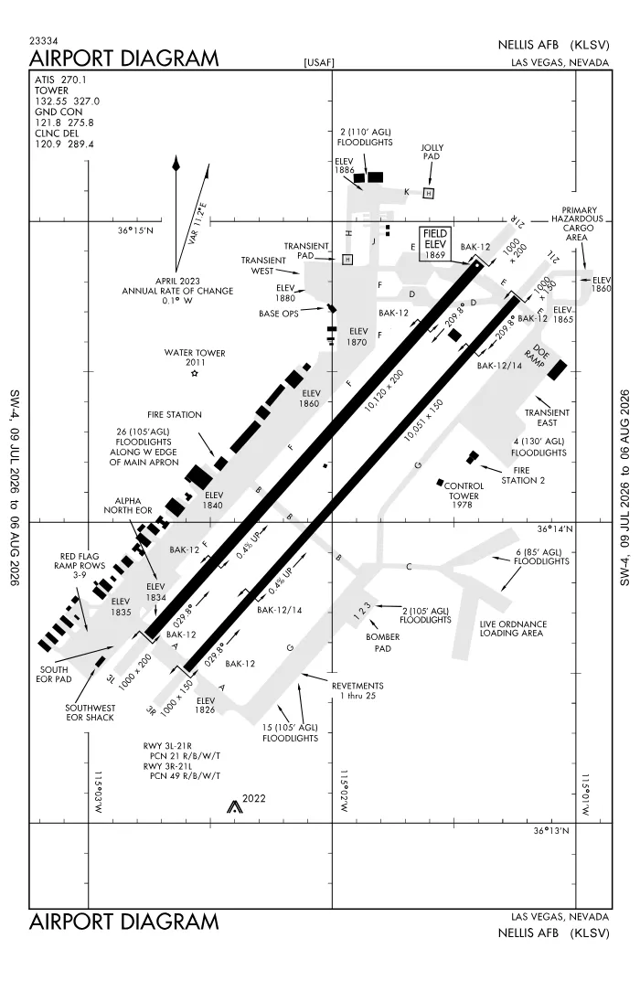 FAA airport diagramView full size ↓
 Nearby now
Loading…
Weather
METAR observed
Loading current weather…
TAF forecast
Loading forecast…
Sun & FAA night2026-09-18 · night begins 07:09 PM
| Event | Local (PDT) | UTC |
|---|---|---|
| Morning civil twilight Loggable night ends | 05:59 AM | 12:59Z |
| Sunrise | 06:25 AM | 13:25Z |
| Sunset | 06:43 PM | 01:43Z |
| Evening civil twilight Loggable night begins | 07:09 PM | 02:09Z |
Plan a flight from KLSV
Past 24 hours category · wind · ceiling · visibility trends
Loading station history…
Density altitude today projected curve · departure window · takeoff roll
Winds aloft NOAA forecast · 3,000 to 53,000 ft
Loading winds aloft…
Full reports: KLSV METAR decoded · KLSV TAF decoded
Advisories
NOTAMs · Loading NOTAMs…
Pilot reports · Loading PIREPs…
Airspace hazards · Checking SIGMETs and G-AIRMETs…
Temporary flight restrictions · Checking for TFRs…
Runways
RWY 03LRIGHT trafficRP · charted
- Heading
- 029° mag · 041° true
- Dimensions
- 10,120 × 200 ft
- TPA
- 2,900 ft MSL (≈1,000 AGL) · standard
- Surface
- Concrete
- Lights
- 4-light PAPI (left) (3°)
More details — RWY 03L
- Threshold elev
- 1,834 ft
- Markings
- precision
- Threshold crossing height
- 52 ft
- TDZ elevation
- 1,841 ft
- Arresting gear
- BAK-12
Pattern side: FAA NASR · TPA standard 1,000 ft AGL (not charted) · layout: FAA runway-end coordinates
| Runway | Length | Your margin |
|---|---|---|
| 03L/21R | 10,120 ft | |
| 03R/21L | 10,051 ft | |
| H1/ | 100 ft |
Prefer one flat page? Full runway details for KLSV → · New to pattern entries? The 45° entry, explained → · Teaching here? Print the KLSV kneeboard →
Comms & NavAids
Communication frequencies
Before taxi
“Nellis”Taxi & takeoff
“Nellis”Departure
“Nellis”Arrival
“Nellis”Also
ATC assigns the exact frequency (in your clearance or on handoff) — which one depends on your SID (departing) or STAR (arriving).
By procedure & sector (21 frequencies)
| Frequency | Used by |
|---|---|
| 124.95 | CLASS B (NORTH) |
| 139.3 | PTD |
| 243.0 | EMERG |
| 270.1 | ATIS |
| 273.55 | CLASS B (NORTH) |
| 275.8 | GND/P |
| 289.4 | CD/P |
| 291.725 | APCH/P |
| 305.6 | SOF (CALL BULLSEYE SOF) |
| 320.0 | COMD POST (ACC HAVE QUICK TIMING AVBL) |
| 321.1 | SFA |
| 323.9 | PMSV METRO |
| 326.2 | SFA |
| 327.0 | LCL/P |
| 340.2 | OPS (AF OPS) |
| 344.6 | PMSV METRO |
| 350.225 | DEP/P |
| 372.2 | PTD |
| 381.3 | COMD POST (ACC RAYMOND 22) |
| 385.5 | SFA |
| 397.2 | SFA |
Source: FAA NASR (current 28-day cycle).
Instrument landing systems
RWY 21L
| Runway | ILS |
|---|---|
| RWY 21L | LOC/GS · CAT I · LOC 109.1 (DIQ) · GS 3.00° |
Source: FAA NASR (current 28-day cycle).
Nearby navigation aids
LSV 135.50 · LAS 116.90 · BLD 116.70 · +1
| NavAid | Type | Freq · ch | Range | Radial / Dist magnetic |
|---|---|---|---|---|
| LSV · Nellis | TACAN | 135.50 · 12X | — | r208° / 0.7 NM |
| LAS · Las Vegas | VORTAC | 116.90 · 116X | High | r018° / 11.2 NM |
| BLD · Boulder City | VORTAC | 116.70 · 114X | High | r315° / 16.6 NM |
| INS · Indian Springs | TACAN | 114.00 · 87X | — | r109° / 37.2 NM |
Prefer one flat list? All KLSV frequencies →
Charts & procedures
Lowest minimums here: ILS with vertical guidance · VFR sectional →
Airport info
From the field
Do you run KLSV, or an FBO, flight school, or shop on it? Claim your listing to keep fuel, fees, hours, and services current.
Airport information
- ICAO / FAA LID
- KLSV / LSV
- Coordinates
- 36.2362, -115.0343
- Elevation
- 1,869 ft MSL
- Magnetic variation
- 12E
- Sectional chart
- LAS VEGAS
- Airport use
- Private
- Control tower
- Yes
- Tower hours
- 24 hours
- ARTCC
- LOS ANGELES (ZLA)
- Flight service (FSS)
- RENO · 1-800-WX-BRIEF
- NOTAM facility
- LSV
- Attendance
- ALL ALL
- Beacon
- white-green (SS-SR)
- Segmented circle
- No
- Wind indicator
- yes
- Activated
- 1937/11
- Distance from city
- 7 NE
Activity & hazards NASR
- Parachute jumping — to 17,500 ft AGL · SAT-SUN SR-SS OTHER TIMES BY NOTAM. · 1.3 NM EAST OF RWYS
Night operations
- Airport lighting
- SEE RMK
- Rotating beacon
- white-green · SS-SR
Runway lighting aids — 03L: 4-light PAPI (left) · 21R: 4-light PAPI (left) · 03R: 4-light PAPI (left) + ALSF1 · 21L: 4-light PAPI (left) + ALSF1.
FAA night windows (civil twilight, loggable night §1.1, currency §61.57) are under Sun & FAA night in the Weather section.
Services fuel · repairs · oxygen · attendance
- Fuel available
- A++
- Bottled oxygen
- NONE
- Bulk oxygen
- HIGH/LOW
- Airframe service
- MAJOR
- Powerplant service
- MAJOR
- Parking
- hangars
- Other services
- Cargo
Ownership & management 2 contacts
Remarks FAA · 26 notes
General
- SERVICE- LGT: RWY THR LGTS GATED.
- JASU: NO STARTER UNIT OR CAPABILITY FOR F4B, F4J; NO STARTER PROBE FOR USN ACFT; 2(MA-1A).
- FLUID: W-EXP 2-3 HR DELAY; SP PRESAIR LHOX LOX.
- OIL: O-123-128-132-133-148-156 SOAP.
- RSTD: BIRD WATCH COND MOD; OPS RSTD; TKOF OR LDG PMSN ONLY WHEN DEP & ARR AVOID BIRD ACT; LCL IFR/VFR TFC PAT NA. BIRD WATCH COND SVR; TKOF OR LDG NA WO OG/CC APVL.
- CTN: STEEPLY RISING TRRN COMMENCING 2.7 NM EAST OF RWY 03R-21L CNTRLN UP TO 3359 MSL. HIGH POTENTIAL FOR HYDROPLANING ON BOTH RWYS DUR WET CONDS. ACFT TAXG ON TWY D BTN TWY F AND RWY 21R USE CTN, 4 FT 8 INCH HI DSTC RMNG SIGN LCTD 125 FT NORTH OF TWY D CNTRLN. HVY ACFT ENG RUNS PMTD ON RWY; REQ MUST BE SKED THRU AIRFIELD MGMT OPS DSN 68204600. DUE TO FOD PROBLEM, 4 ENG ACFT WILL TAXI WITH OUTBOARD ENGS AT IDLE PWR OR SHTDN IF PSBL. JOLLY AND TSNT HELIPADS MISG MANDATORY HOLD POS SIGNS. RWY CONDS NOT RPRTD.
- TFC PAT: DEP CLIMB ABV 3000 FT NA UNTIL DER.
- RSTD: SUN & HOL EXP ARR FM N; DEP FM N WINDS PERM; TFC PAT TWDS E.
- MISC: NO CLASSIFIED MTRL STORAGE AVBL AT AM OPS; CLASSIFIED MUST BE STORED IN NELLIS AFB COMMAND POST. TSNT ACFT SHALL COMMUNICATE WITH NELLIS ATC ON UHF TO MAX EXTENT PSBL DUE TO HVY CONCENTRATION OF ACFT IN THE VFR PAT. RSRS WILL BE APPLIED TO BASE ASGND/DEPLOYED ACFT.
- MISC: WX OBS VIEW OF AER 03R/L RSTD 190-330 DEG BY FLIGHTLINE BLDGS & FAC & AT NGT DUE TO RAMP LGT.
- MISC: WX SUPPORT H24 - DSN 682-4744, C702-652-4744; MSN SUPPORT WX PER WING & EXER SKED TYPICALLY 1300++ MON THRU 0530++ FRI CLSD WKND & HOL; TSNT WX AFT HR VIA DAVIS MONTHAN 25OWS - D228-6598/6599, C520-228-6598/6599.
- HOT CARGO PAD UNLIT; RSTD TO DAYLIGHT/VFR OPS.
- A-GEAR: ALL BAK-12B EXTN & IN RAISED POSN, RQR 30 MIN PN FOR REMOVAL.
- SVC-TSNT ALERT: AVBL MON-FRI 1600Z-0400Z++, NO QUICK TURN FRI-SUN. NO MIL FLEET SVC AVBL. LTD TSNT SVC AVBL. TSNT ALERT CONTRACT BACKSHOP MAINT SUPPORT MAY RQR REIMBURSEMENT AND COORD WITH CONTRACT OFFICER. DUE TO LARGE NR OF TSNT AND EXER ACFT EXP DELAYS WITH TRAN ALERT.
- RSTD: FORWARD FIRING MUNITIONS IN REVETMENTS 12, 13 & 25 NA.
- CTN: INCREASED DURG BASH PHASE II APR-MAY & AUG-OCT.
- SERVICE-A-GEAR: RWY 03R-21L BAK-14 OPS: BOTH BAK-14 APCH END AND DEP END WILL BE IN LOWERED POS. AVBL UPON REQ FOR EMER USE ONLY. SLOW TO 20 KTS OR LESS PRIOR TO DEP END CABLE & TAXI TO FAR EDGE OF COLD SIDE OF RWY; TAXI BTN RWY EDGE & OUTERMOST BAK-14 BUMPER.
- CTN: TWY A EAST TACAN CK POINT SIGN NSTD.
- SERVICE-LGT: TWY EDGE LGTS ADJ TO MAIN APN PRKG ROWS 1 & 2 MISG.
- RSTD: ALL TSNT ACFT MUST OBTAIN PPR PRIOR TO ARR. REFER TO NELLIS NOTAMS TO ID AVBL AIRFIELD SVCS WINDOW. PPR MAY BE ISSUED UP TO 7 DAYS PRIOR TO, BUT NLT 48 HRS PRIOR TO SKED ARR. PPR FOR ALL ACFT; CTC AM OPS DSN 682-4601, C702-652-4601. RON REQ GOOD FOR ONE NGT ONLY, DEPENDENT UPON RAMP SPACE. TRAN FTR, NON EXER ACFT, PRKG LMTD TO ROWS 45-46. ACFT MUST ADHERE TO PPR ARR BLOCK +/- 30 MINS OF SKED LDG. MULT APCH NA DURG RF/LFE OR AFT OFFL SS UNLESS APVD BY 57 WG SOF. ACFT PTCPG IN NELLIS SPONSORED EXERS/LARGE FORCE EXERS RQR LCL SPONSORING UNIT. THE LCL SPONSORING UNIT WILL COORD MAINT, PRKG, AND SVCS. PL-2 ACFT MUST BRING OWN SCTY PSNL AND DETAIL FOR ALL LARGE FORCE EXERS. FOR CSTMS AND AG, CTC NELLIS SUPPORT CNTR FOR ACFT WITH WIGNSPANS OF 132.6 FT OR LRGR AT DSN 682-5250 OR CTC BASE OPS FOR ALL OTHER ACFT AT DSN 682-4601 WITH 24 HR PN. SUN AND HOL TFC EXPC ARR FM NORTH, DEP ACFT NORTH WINDS PMTD WITH TFC PAT TWD EAST (SUNRISE MT). PROGRESSIVE TAXI AVBL. ACFT WITH DV CODE 7 OR HYR CTC PTD WHEN 100 NM OUT. ALL INBD PAX/CARGO AND DV ACFT MUST CTC COMMAND POST (GAMBLER 99) ON 381.300 NLT 30 MINS PRIOR TO LDG. B-52 OPS LTD TO 380K LB.
- COMMUNICATIONS-SOF: REMARKS: (CALL BULLSEYE SOF); LCL EMERG FREQ 343.725.
Runways
- STEEP RISING TRRN S & E OF CNTRLN; RWY 03R/21L PROVDS BTR BA THAN RWY 03L/21R WHEN WET; RWY 03R/21L UNGROOVED; USE CTN FOR HYDROPLANING.
- FIRST 1320 FT RWY 21R & 920 FT RWY 03L GROOVED CONCRETE; MID 7879 FT CNTR 80 FT CONC RMNG ASPH.
- 9000-10000 DIST RMNG MKR E SIDE NA.
- RWY 03R - 03L PAPI LED. RWY 21R - 21L PAPI INCANDESCENT.
Lighting
- RWY 03R & 21L ALSF-1 APCH LGTS NTE STEP 3 INTST.
Embed KLSV weather on your site free widget for schools, clubs & FBOs
Live METAR, flight category, and favored runway for KLSV — paste this into your website's HTML. It updates automatically and stays free.
More widgets — crosswind, E6B, density altitude — on the embed page.
Nearby airports
Loading nearby conditions…
About KLSV
Nellis AFB (LSV · KLSV) is an airport in Las Vegas, NV, at 1,869 ft MSL. It has 3 runways, the longest 10,120 ft, with a control tower. This page shows live METAR/TAF weather, runway crosswinds, frequencies, navaids, and FAA charts for KLSV, refreshed from the Aviation Weather Center and FAA NASR.
Does KLSV have a control tower?
Yes. Nellis AFB has an operating FAA control tower. See the Comms & NavAids section for tower and ground frequencies.
What is the longest runway at KLSV?
Nellis AFB has 3 runways; the longest is 10,120 ft. See the Runways section for headings, surface, and lighting.
Where is KLSV?
Nellis AFB is in Las Vegas, NV, at an elevation of 1,869 ft MSL. Coordinates: 36.2362, -115.0343.
More about KLSV
Weather is live from the Aviation Weather Center; airport facility data is from the FAA NASR (28-day cycle). For planning and education only; always verify against official sources. Open KLSV in a full tool: METAR/TAF decoder, crosswind calculator, sun & night times, or the density altitude calculator. Planning from here? Find the nearest airport with fuel or an approach, or check whether an IFR alternate is required.
Something here wrong or out of date? Report a data problem.