
Jacksonville NAS (Towers Field) Private
NIP · KNIP · Jacksonville, FL · Towered · Print kneeboard · Open on the map
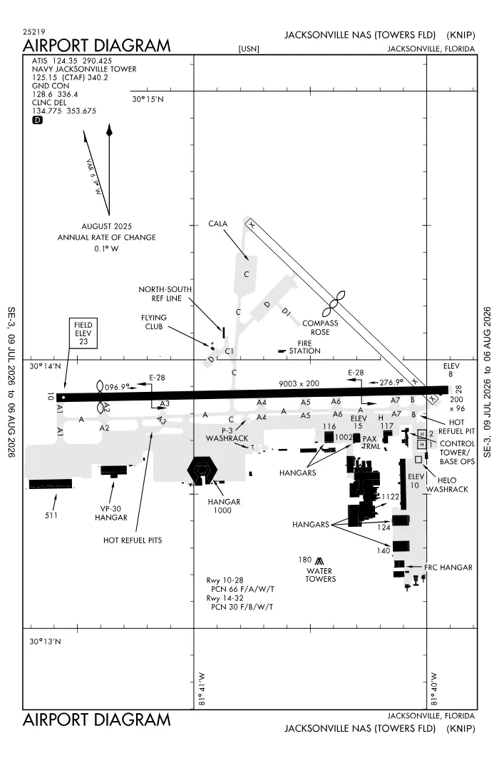 FAA airport diagramView full size ↓
 Nearby now
Loading…
Weather
METAR observed
Loading current weather…
TAF forecast
Loading forecast…
Sun & FAA night2026-09-18 · night begins 07:53 PM
| Event | Local (EDT) | UTC |
|---|---|---|
| Morning civil twilight Loggable night ends | 06:49 AM | 10:49Z |
| Sunrise | 07:13 AM | 11:13Z |
| Sunset | 07:29 PM | 23:29Z |
| Evening civil twilight Loggable night begins | 07:53 PM | 23:53Z |
Plan a flight from KNIP
Past 24 hours category · wind · ceiling · visibility trends
Loading station history…
Density altitude today projected curve · departure window · takeoff roll
Winds aloft NOAA forecast · 3,000 to 53,000 ft
Loading winds aloft…
Full reports: KNIP METAR decoded · KNIP TAF decoded
Advisories
NOTAMs · Loading NOTAMs…
Pilot reports · Loading PIREPs…
Airspace hazards · Checking SIGMETs and G-AIRMETs…
Temporary flight restrictions · Checking for TFRs…
Runways
RWY 10LEFT traffic
- Heading
- 096° mag · 090° true
- Dimensions
- 9,003 × 200 ft
- TPA
- 1,000 ft MSL (≈1,000 AGL) · standard
- Surface
- Asphalt
- Lights
- 4-light PAPI (left) (3°) + ALSF1
- ILS
- ILS/DME · CAT I · LOC 109.15 (NTW) · GS 3.00°
- Displaced thr
- 997 ft
- CTAF
- 125.15
More details — RWY 10
- Threshold elev
- 23 ft
- Markings
- precision
- Threshold crossing height
- 51 ft
- TDZ elevation
- 21 ft
- Declared TORA/TODA/ASDA/LDA
- 9,003 / 9,003 / 9,003 / 8,006 ft
- End lights
- REIL, centerline
- Arresting gear
- E28
Pattern side + displaced threshold: FAA NASR · TPA standard 1,000 ft AGL (not charted) · layout: FAA runway-end coordinates
| Runway | Length | Your margin |
|---|---|---|
| 10/28 | 9,003 ft | |
| 14/32 | 5,978 ft |
Prefer one flat page? Full runway details for KNIP → · New to pattern entries? The 45° entry, explained → · Teaching here? Print the KNIP kneeboard →
Comms & NavAids
Communication frequencies
Before taxi
“Navy Jacksonville”Taxi & takeoff
“Navy Jacksonville”Departure & arrival
“Jacksonville”Arrival
“Jacksonville”Also
ATC assigns the exact frequency (in your clearance or on handoff) — which one depends on your SID (departing) or STAR (arriving).
By procedure & sector (11 frequencies)
| Frequency | Used by |
|---|---|
| 127.0 | ALCRN STAR |
| 243.0 | EMERG |
| 269.9 | ALCRN STAR |
| 290.425 | ATIS |
| 307.325 | LCL/S |
| 336.4 | GND/P |
| 340.2 | LCL/P |
| 343.5 | PMSV METRO |
| 353.675 | CD/P |
| 377.075 | APCH/P DEP/P |
| 6723.0 | ATCOM |
Source: FAA NASR (current 28-day cycle).
Instrument landing systems
RWY 10 · RWY 28
| Runway | ILS |
|---|---|
| RWY 10 | ILS/DME · CAT I · LOC 109.15 (NTW) · GS 3.00° |
| RWY 28 | ILS/DME · CAT I · LOC 109.15 (NIP) · GS 3.00° |
Source: FAA NASR (current 28-day cycle).
Nearby navigation aids
NIP 108.20 · CRG 114.50 · NRB 111.40
| NavAid | Type | Freq · ch | Range | Radial / Dist magnetic |
|---|---|---|---|---|
| NIP · Jacksonville | TACAN | 108.20 · 19X | — | r287° / 0.3 NM |
| CRG · Craig | VORTAC | 114.50 · 92X | High | r238° / 10.8 NM |
| NRB · Mayport | TACAN | 111.40 · 51X | — | r242° / 16.2 NM |
Prefer one flat list? All KNIP frequencies →
Charts & procedures
Lowest minimums here: RNAV (RNP) with vertical guidance · VFR sectional →
Airport info
From the field
Do you run KNIP, or an FBO, flight school, or shop on it? Claim your listing to keep fuel, fees, hours, and services current.
Airport information
- ICAO / FAA LID
- KNIP / NIP
- Coordinates
- 30.2337, -81.6761
- Elevation
- 22 ft MSL
- Magnetic variation
- 6W
- Sectional chart
- JACKSONVILLE
- Airport use
- Private
- Control tower
- Yes
- Tower hours
- 24 HRS. SEE FLIP AP/1 SUPPLEMENT ARPT INFO. CLOSURES PUBLISHED VIA NOTAM.
- Airspace
- Class D
- Weather station
- AWOS-3 · 124.35
- ARTCC
- JACKSONVILLE (ZJX)
- Flight service (FSS)
- GAINESVILLE · 1-800-WX-BRIEF
- NOTAM facility
- NIP
- Attendance
- ALL 1200-0400Z
- Beacon
- S-white-green (SS-SR)
- Segmented circle
- No
- Activated
- 1941/05
- Distance from city
- 4 S
Night operations
- Airport lighting
- SEE RMK
- Rotating beacon
- S-white-green · SS-SR
- Pilot-controlled lighting
- Usually keyed on CTAF 125.15 — confirm the click sequence in the Chart Supplement ↗
Runway lighting aids — 10: 4-light PAPI (left) + ALSF1 · 28: 4-light PAPI (right) + ALSF1.
FAA night windows (civil twilight, loggable night §1.1, currency §61.57) are under Sun & FAA night in the Weather section.
Services fuel · repairs · oxygen · attendance
- Fuel available
- Jet (JP-5)
- Bottled oxygen
- NONE
- Bulk oxygen
- NONE
- Airframe service
- NONE
- Powerplant service
- NONE
Ownership & management 2 contacts
Remarks FAA · 29 notes
General
- JASU: 1(NCPP-105) 2(NC-8)
- FLUID: LOCAL SQUADRONS CTC CRYOGENIC PLANT FOR LOX SVC, DSN 942-3818, C904-542-3818, 1200-2030Z++ MON-FRI. LOX SERVICE IS NOT AVAILABLE FOR TRANSIENT AIRCRAFT.
- TRANS ALERT: LTD TRAN MAINT, SVC AND SPACE. ACFT STAIRS AVBL 1230-0300Z++ DLY WITH 24 HR NTC.
- RSTD: TRAN JET ACFT VFR TGL NA WO CRS RULES BRF. ALL ACFT CTC FLT PLNG 310.2, 134.775 15 MIN PRIOR TO LDG.
- CAUTION: EXER EXTREME VIGILANCE DUR IFR APCH RWY 10 IN VMC DUE TO GENERAL AVIATION ACFT VICINITY CECIL FLD.
- CAUTION: UNSHIELDED LGT AT BALLFIELD NIP 216/2.4 NM ON RWY 10 APCH.
- 48 HR PPR NTC REQ EXC AIREVAC, JOSAC, NALO, AND LIFEFLTS, CTC BASEOPS DSN 942-5211, C904-542-2511. BOQ DSN 942-3138/3427/3139.
- NS ABTMT: STOP LDG ONLY MON-SAT BTN 0300-1300Z++ & SUN BTN 0300-1700Z++.
- CSTMS/AG/IMG: ACFT RQR INSPECTION CTC AFLD MGR DSN 942-3176, C904-542-3176 AT LEAST 48 HRS PRIOR TO ARR TO COORD INSPECTION SETUP.
- MISC: VIP ACFT CTC BASE OPS PRIOR LDG.
- CAUTION: TO PRECLUDE TAIL HOOK SKIP DURG A-GEAR ENGAGEMENT, AVOID RWY 10/28 CNTRLN LGTS LCTD 24 INCHES SOUTH OF RWY CNTRLN. MAX SAFE OFF-CNTR ARRESTMENT 40 FT.
- RSTD: AFLD CLSD 2ND WED OF EV MONTH FOR AFLD MAINT FR 1200-1600Z++.
- RSTD: PPR FOR ALL TRAN ACFT EXC AIREVAC AND LIFEFLTS, CTC AFLD MGR 48 HR PRIOR TO ARR FOR PPR NR. PPR & CALP REQ WILL CALL DSN 942-3176, C904-542-3176. BOQ DSN 942-3138/3427/3139.
- MISC: CTC NAVAL ATLANTIC MET FAC JACKSONVILLE FOR WX ADVSY OR WX FCST DSN 942-2541, C904-542-2541.
- CAUTION: MAT AREAS N OF RWY 10/28 NOT AUTHORIZED FOR ACFT USE.
- CAUTION: EXTREME BIRD HAZ DUR SUMMER MONTHS. CTC TWR FOR CURRENT BASH COND.
- CAUTION: SKYDIVING AND GLIDER OPERATIONS , SFC TO 10,000 FT, 7 MILES, IN VICINITY OF HERLONG ARPT, BTN SR & SS.
- MISC: AIRCREWS ARE RESPONSIBLE FOR THEIR ON/OFF BASE TRANSPORTATION. AIRCREWS COORDINATE FOR CLASSIFIED MATERIAL STORGE WITH NCTAMSLANT AT DSN 942-3777 24 HR NTC.
- MISC: WX FCST SVC AVBL 0900-0100Z++ MON-FRI. ALL OTHER HOURS WX OBSERVER ONLY. CTC FWC-N AVN CP JAX AT DSN 942-2535 C904-542-2535. CTC NAVAL AVAITION FCST CNTR FOR WX ADVSY OR WX FCST DSN 564-2594, C757-444-2594 DURING OTHER HRS.
- JASU -1(NC-10) 1 (MSU-200NAVIA/U47A-5(HUFFER) QLFD AIRCREW RQRD.
- AMC TRML-HRS 1230-0300++ MON-FRI.
- A-GEAR: RWY 10-28 A-G RIGGED UPON REQ 15 MIN NTC FOR ARRESTMENT ON RWY 10-28.
Runways
- OPTICAL LANDING SYSTEM (OLS) & WAVE-OFF
- OPTICAL LANDING SYSTEM (OLS) & WAVE-OFF
Lighting
- ACTIVATE-ALSF-1 RWY 10; SALSF RWY 28; PAPI RWY 10 & 28; HIRL RWY 10/28 - 134.775.
- FOR ACFT OPR IAW NASJAXINST 3710.1.
- OLS & WAVE-OFF
Fuel
- J5 FUELS DIV DSN 942-3906, C 904-542-3906
Attendance
- OPR 1200-0400Z (DT 1100-0300) DLY. CLSD FEDERAL HOLS; OT BY NOTAM.
Embed KNIP weather on your site free widget for schools, clubs & FBOs
Live METAR, flight category, and favored runway for KNIP — paste this into your website's HTML. It updates automatically and stays free.
More widgets — crosswind, E6B, density altitude — on the embed page.
Nearby airports
Loading nearby conditions…
Also nearby: 11FL Williams Field (private) (16 NM)
About KNIP
Jacksonville NAS (Towers Field) (NIP · KNIP) is an airport in Jacksonville, FL, at 22 ft MSL. It has 2 runways, the longest 9,003 ft, with a control tower. This page shows live METAR/TAF weather, runway crosswinds, frequencies, navaids, and FAA charts for KNIP, refreshed from the Aviation Weather Center and FAA NASR.
Does KNIP have a control tower?
Yes. Jacksonville NAS (Towers Field) has an operating FAA control tower. See the Comms & NavAids section for tower and ground frequencies.
What is the longest runway at KNIP?
Jacksonville NAS (Towers Field) has 2 runways; the longest is 9,003 ft. See the Runways section for headings, surface, and lighting.
Where is KNIP?
Jacksonville NAS (Towers Field) is in Jacksonville, FL, at an elevation of 22 ft MSL. Coordinates: 30.2337, -81.6761.
More about KNIP
Weather is live from the Aviation Weather Center; airport facility data is from the FAA NASR (28-day cycle). For planning and education only; always verify against official sources. Open KNIP in a full tool: METAR/TAF decoder, crosswind calculator, sun & night times, or the density altitude calculator. Planning from here? Find the nearest airport with fuel or an approach, or check whether an IFR alternate is required.
Something here wrong or out of date? Report a data problem.