
Dyess AFB Private
DYS · KDYS · Abilene, TX · Towered · Print kneeboard · Open on the map
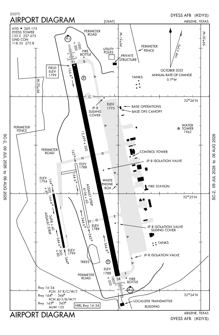 FAA airport diagramView full size ↓
 Nearby now
Loading…
Weather
METAR observed
Loading current weather…
TAF forecast
Loading forecast…
Sun & FAA night2026-09-18 · night begins 08:06 PM
| Event | Local (CDT) | UTC |
|---|---|---|
| Morning civil twilight Loggable night ends | 07:00 AM | 12:00Z |
| Sunrise | 07:25 AM | 12:25Z |
| Sunset | 07:42 PM | 00:42Z |
| Evening civil twilight Loggable night begins | 08:06 PM | 01:06Z |
Plan a flight from KDYS
Past 24 hours category · wind · ceiling · visibility trends
Loading station history…
Density altitude today projected curve · departure window · takeoff roll
Winds aloft NOAA forecast · 3,000 to 53,000 ft
Loading winds aloft…
Full reports: KDYS METAR decoded · KDYS TAF decoded
Advisories
NOTAMs · Loading NOTAMs…
Pilot reports · Loading PIREPs…
Airspace hazards · Checking SIGMETs and G-AIRMETs…
Temporary flight restrictions · Checking for TFRs…
Runways
RWY 16LEFT traffic
- Heading
- 164° mag · 169° true
- Dimensions
- 13,500 × 300 ft
- TPA
- 2,800 ft MSL (≈1,000 AGL) · standard
- Surface
- Concrete
- Lights
- 4-light PAPI (left) (2.6°) + ALSF1
- ILS
- ILS · CAT I · LOC 109.9 (TYY) · GS 2.60°
More details — RWY 16
- Threshold elev
- 1,790 ft
- Markings
- precision
- Threshold crossing height
- 48 ft
- TDZ elevation
- 1,790 ft
Pattern side: FAA NASR · TPA standard 1,000 ft AGL (not charted) · layout: FAA runway-end coordinates
| Runway | Length | Your margin |
|---|---|---|
| 16/34 | 13,500 ft | |
| 163/343 | 3,500 ft | |
| 164/344 | 3,498 ft |
Prefer one flat page? Full runway details for KDYS → · New to pattern entries? The 45° entry, explained → · Teaching here? Print the KDYS kneeboard →
Comms & NavAids
Communication frequencies
Taxi & takeoff
“Dyess”Departure & arrival
“Abilene”Also
ATC assigns the exact frequency (in your clearance or on handoff) — which one depends on your SID (departing) or STAR (arriving).
By procedure & sector (10 frequencies)
| Frequency | Used by |
|---|---|
| 139.3 | PTD |
| 243.0 | EMERG |
| 257.675 | LCL/P |
| 269.175 | ATIS · DYS ASOS |
| 275.8 | GND/P |
| 282.3 | APCH/P DEP/P (WEST) |
| 311.0 | COMD POST (CALL - RAYMOND 37) |
| 338.3 | APCH/P DEP/P (EAST) |
| 372.2 | PTD |
| 383.25 | PMSV METRO |
Source: FAA NASR (current 28-day cycle).
Instrument landing systems
RWY 16 · RWY 34
| Runway | ILS |
|---|---|
| RWY 16 | ILS · CAT I · LOC 109.9 (TYY) · GS 2.60° |
| RWY 34 | ILS · CAT I · LOC 109.9 (DYS) · GS 2.50° |
Source: FAA NASR (current 28-day cycle).
Nearby navigation aids
DYS 133.60 · ABI 113.70 · TQA 114.85
| NavAid | Type | Freq · ch | Range | Radial / Dist magnetic |
|---|---|---|---|---|
| DYS · Dyess | TACAN | 133.60 · 63X | — | r037° / 0.2 NM |
| ABI · Abilene | VORTAC | 113.70 · 84X | High | r163° / 3.7 NM |
| TQA · Tuscola | VOR/DME | 114.85 · 95Y | Low | r340° / 11.3 NM |
Prefer one flat list? All KDYS frequencies →
Charts & procedures
Lowest minimums here: ILS with vertical guidance · VFR sectional →
Airport info
From the field
Do you run KDYS, or an FBO, flight school, or shop on it? Claim your listing to keep fuel, fees, hours, and services current.
Airport information
- ICAO / FAA LID
- KDYS / DYS
- Coordinates
- 32.4185, -99.8565
- Elevation
- 1,790 ft MSL
- Magnetic variation
- 5E
- Sectional chart
- DALLAS-FT WORTH
- Airport use
- Private
- Control tower
- Yes
- Tower hours
- 24 hours
- Airspace
- Class C
- Weather station
- ASOS · 269.175
- ARTCC
- FORT WORTH (ZFW)
- Flight service (FSS)
- FORT WORTH · 1-800-WX-BRIEF
- NOTAM facility
- FTW
- Beacon
- white-green (SS-SR)
- Segmented circle
- No
- Wind indicator
- yes
- Distance from city
- 5 SW
Activity & hazards NASR
- Parachute jumping — to 3,300 ft MSL · SUNRISE-SUNSET, DAILY
Night operations
- Airport lighting
- SS-SR
- Rotating beacon
- white-green · SS-SR
Runway lighting aids — 16: 4-light PAPI (left) + ALSF1 · 34: 4-light PAPI (left) + ALSF1.
FAA night windows (civil twilight, loggable night §1.1, currency §61.57) are under Sun & FAA night in the Weather section.
Services fuel · repairs · oxygen · attendance
- Fuel available
- Jet A (additive)
- Bottled oxygen
- NONE
- Bulk oxygen
- LOW
- Airframe service
- MAJOR
- Powerplant service
- MAJOR
Ownership & management 2 contacts
Remarks FAA · 36 notes
General
- RSTD: INBD ACFT WITH DV CODE 6 OR ABV CTC AFLD OPS 20 MIN PRIOR ARR MON-FRI, CTC COMD POST ON UHF OR DSN 461-1921. 45 MIN PRIOR WKEND AND HOL.
- CAUTION: INTS TRNG AND FORMATION FLT OF HVY ACFT IN THE IMMED VCNTY.
- MISC: ALL AMC ACFT CTC AMCC PRIOR TO ARR DSN 461-1984, C325-696-1984..
- PPR CTC AFLD MGMT AT 7OSS.OSAA.AMOPS@US.AF.MIL FOR PPR REQ FORM DSN 461-2515/2258. MIN 24 HR NOTICE RQR AND REQ NO MORE THAN 7 DAYS PRIOR. PPR VALID +/- 30 MINUTES OF SKED LDG. ALL DIVERTS MUST CTC AFLD MGMT TO CONFIRM RAMP SPACE/TRAN SVC AVBL.
- CSTMS/AG/IMG: CSTMS AVBL, CTC SECURITY FORCES DSN 461-2131/2132 24 HR IN ADVANCE.
- CAUTION: ACFT LRGR THAN C130 ONLY ALLOWED 180 DEG TURNS ON CONC SFC AT N AND S ENDS OF RWY 16-34.
- TFC PAT: DUR VMC DEP ACFT MUST REMAIN AT OR BLW 3000' TIL FLD BDRY TO ENSURE SEPARATION FR VFR OVERHEAD.
- BEARING STRENGTH RWY 161-341: AUW 155.
- TFC PAT: RSRS APPLIES TO ALL LOCAL ACFT. B1 8000', C130 5000' SEPARATION, B1 RQR MIN CEIL/VIS 1500'/3 SM AND RWY SFC DRY.
- JASU: 1(MD-3) 1(A/M32A-60A) 1(A/M32A-86) 1(A/M32A-95).
- FLUID: LPOX DE-ICE.
- OIL: O-133-148-156.
- CAUTION: EXTV VFR ASSAULT STRIP TFC W OF RWY 16-34.
- CAUTION: AFLD SIGNS RQR B52 ACFT EXIT RWY 16-34 AT TWY F.
- SERVICE: TRAN ALERT SVC AVBL MON-FRI 1400-0400Z++; CLSD WKEND AND HOL.
- CAUTION: DURING BWC MODERATE AND SEVERE, AIRCREWS SHOULD COMPLY WITH OWNING MAJCOM/UNIT GUIDANCE; AIRCREWS CAN OBTAIN CURRENT BWC FR ATIS/PTD. BASH PHASE II IN EFFECT APR - JUN AND SEP - NOV.
- CAUTION: COMSEC STORED AT COMMAND POST.
- RSTD: NO ARR/DEP WHEN LIGHTNING WI 5 NM WO OG/CC APVL.
- RSTD: QUIET HR POLICY 0400-1000Z++.
- MISC: AFLD WX MNT BY AN/FMQ-19 ASOS, AUGMENTED BY HUMAN OBSN WHEN RQR. ATC WILL RELAY TWR PREV VIS, RCR/RSC AND VIRGA RMK TO ACFT. AUGMENTED SFC VIS RSTD 090-160 BY BLDG.
- MISC: FOR CUSTOMS REFER TO FCG OR AP-1.
- RSTD: PPR VALID +/- 30 MINUTES. PPR WILL NOT BE ISSUED FOR TRAN ACFT REQ RWY 163/343 AND RWY 164/344. LZ164/344 HAS A NON-STD LTG SYS. TRAN ACFT MUST OBTAIN BRIEFING FM 317 OSK PRIOR TO NGT OPNS. WITHOUT FORMAL NOTIFICATION FROM 317 OSK, TRAN ACFT USING RWY 163/343 OR 164/344 AT NGT WITHOUT LGT (OVERT OR COVERT) AND WITH RESPECTIVE MAJCOM/A3 APVL MUST NOTIFY AFLD MGMT AND REQ SEPARATE NOTAM FOR UNLGTD LZ OPNS.
- PARK SPOTS A1 AND B1 USED FOR TAXI OPNS ONLY.
- RSTD: PRK SPOTS A12, A13 AND A20 ARE DESIGNATED ACFT GRD EQPT (AGE) SPOTS.
- RSTD: TYE RAMP CLSD.
- RSTD: TWY G RSTD TO DAYLT OPS ONLY; EXC NVG OPS AND MAINT TOW.
- SERVICE-FUEL: A+ IS NATO F-24 EQUIVALENT WITH EXTRA ADDITIVES (CI/LI AND SDA).
- RSTD: PRK SPOTS A1 & B1 AVBL FOR TAXI ONLY.
- COMMUNICATIONS-TWR: UHF EQUIPPED ACFT SHALL USE 257.675 TO MAX EXTENT POSSIBLE.
- MISC: WX FCST SVC AVBL DUR AFLD OPR HRS; DSN 461-2524, C325-696-2524. ALL 175-1 WX REQ RQR 2 HR NOTICE.
- TRAN ALERT: NO MIL FLEET SVC AVBL, LTD TRAN SVC AVBL.
- CAUTION: NMRS UNMKD SPALLS THRU OUT RWY 16/34. CTC AFLD MGMT OPS DSN 461-2515 FOR FURTHER INFO.
- RSTD: B-52 ACFT APCH/LDG DYESS AFB MUST PRVD AT LEAST 2-4 HRS NOTICE BFR ARR FOR AFLD PREP.
- OPRG HRS: OPR 1300-0559Z++ MON-FRI FOR ALL ACFT, 1500-2300Z++ SAT-SUN FOR 7 BW AND 317 AW ONLY; CLSD HOL, HOL WKEND AND AFGSC FAM DAYS. IN CASE OF AFT HR EMERG NTFY 7 BW COMD POST AT 325-696-1921.
- MISC: FIRE BOTTLES LCTD AT N AND S HAMMERHEADS.
Runways
- RWY LNDG ZONE CLSD.
Embed KDYS weather on your site free widget for schools, clubs & FBOs
Live METAR, flight category, and favored runway for KDYS — paste this into your website's HTML. It updates automatically and stays free.
More widgets — crosswind, E6B, density altitude — on the embed page.
Nearby airports
Loading nearby conditions…
Also nearby: 35TX Flying B Ranch Airstrip (private) (4 NM) · 82TS Elmdale Airpark (private) (11 NM) · 91XS Stark Field (private) (11 NM) · TX00 Abilene Executive Airpark (private) (12 NM) · 32TT The Mesquite Bean (private) (16 NM)
About KDYS
Dyess AFB (DYS · KDYS) is an airport in Abilene, TX, at 1,790 ft MSL. It has 3 runways, the longest 13,500 ft, with a control tower. This page shows live METAR/TAF weather, runway crosswinds, frequencies, navaids, and FAA charts for KDYS, refreshed from the Aviation Weather Center and FAA NASR.
Does KDYS have a control tower?
Yes. Dyess AFB has an operating FAA control tower. See the Comms & NavAids section for tower and ground frequencies.
What is the longest runway at KDYS?
Dyess AFB has 3 runways; the longest is 13,500 ft. See the Runways section for headings, surface, and lighting.
Where is KDYS?
Dyess AFB is in Abilene, TX, at an elevation of 1,790 ft MSL. Coordinates: 32.4185, -99.8565.
More about KDYS
Weather is live from the Aviation Weather Center; airport facility data is from the FAA NASR (28-day cycle). For planning and education only; always verify against official sources. Open KDYS in a full tool: METAR/TAF decoder, crosswind calculator, sun & night times, or the density altitude calculator. Planning from here? Find the nearest airport with fuel or an approach, or check whether an IFR alternate is required.
Something here wrong or out of date? Report a data problem.