
Harry Reid International
LAS · KLAS · Las Vegas, NV · Towered · Print kneeboard · Open on the map
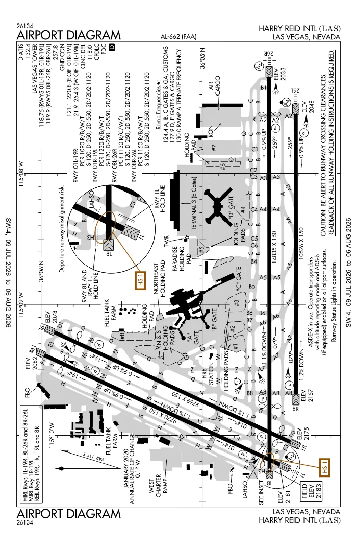 FAA airport diagramView full size ↓
 Nearby now
Loading…
Weather
METAR observed
Loading current weather…
TAF forecast
Loading forecast…
Sun & FAA night2026-09-18 · night begins 07:09 PM
| Event | Local (PDT) | UTC |
|---|---|---|
| Morning civil twilight Loggable night ends | 06:00 AM | 13:00Z |
| Sunrise | 06:25 AM | 13:25Z |
| Sunset | 06:44 PM | 01:44Z |
| Evening civil twilight Loggable night begins | 07:09 PM | 02:09Z |
Plan a flight from KLAS
Past 24 hours category · wind · ceiling · visibility trends
Loading station history…
Density altitude today projected curve · departure window · takeoff roll
Computing today's density altitude…
Winds aloft NOAA forecast · 3,000 to 53,000 ft
Loading winds aloft…
Full reports: KLAS METAR decoded · KLAS TAF decoded
Advisories
NOTAMs · Loading NOTAMs…
Pilot reports · Loading PIREPs…
Airspace hazards · Checking SIGMETs and G-AIRMETs…
Temporary flight restrictions · Checking for TFRs…
Runways
RWY 08LLEFT traffic
- Heading
- 079° mag · 090° true
- Dimensions
- 14,835 × 150 ft
- TPA
- 3,200 ft MSL (≈1,000 AGL) · standard
- Surface
- Concrete
- Lights
- 4-light PAPI (left) (3°)
- Displaced thr
- 2,459 ft
- CTAF
- 122.95
More details — RWY 08L
- Threshold elev
- 2,183 ft
- Markings
- nonprecision
- Approach obstacle
- Hangar, 25 ft, 200 ft from threshold, 500 ft L of centerline — 50:1 slope to clear
- Threshold crossing height
- 76 ft
- TDZ elevation
- 2,155 ft
- Declared TORA/TODA/ASDA/LDA
- 14,835 / 15,419 / 14,419 / 11,960 ft
Pattern side + displaced threshold: FAA NASR · TPA standard 1,000 ft AGL (not charted) · layout: FAA runway-end coordinates
| Runway | Length | Your margin |
|---|---|---|
| 08L/26R | 14,835 ft | |
| 08R/26L | 10,526 ft | |
| 01L/19R | 9,770 ft | |
| 01R/19L | 9,769 ft |
Prefer one flat page? Full runway details for KLAS → · New to pattern entries? The 45° entry, explained → · Teaching here? Print the KLAS kneeboard →
Comms & NavAids
Communication frequencies
Before taxi
“Las Vegas”Taxi & takeoff
“Las Vegas”Departure
“Las Vegas”Arrival
“Las Vegas”Also
ATC assigns the exact frequency (in your clearance or on handoff) — which one depends on your SID (departing) or STAR (arriving).
By procedure & sector (17 frequencies)
| Frequency | Used by |
|---|---|
| 119.775 | BLAID STAR · CHOWW STAR · CLASS B (030-110 LAS) · ISHEE STAR · RKSTR STAR |
| 120.45 | ARR (VFR ARR) |
| 124.4 | RAMP CTL (A, B, C GATES & GA, CUSTOMS.) |
| 125.025 | CLASS B (200-300 LAS) · COKTL STAR · GAMES STAR · GAMES STAR (PROPS;) · JAYSN STAR · LARKK STAR · PUMLE STAR · RNDRZ STAR |
| 125.475 | CLASS B (110-200 LAS) · CRESO STAR |
| 125.9 | HOOVER DP (RWY 19L/R, RWY 26L/R) · JOHKR DP · LOHLA DP (RWY 1L/R, RWY 8L/R) · MCCARRAN DP · NIITZ DP (RWY 19L/R, RWY 26L/R) · RADYR DP · RASLR DP (RWY 19L/R, RWY 26L/R) · RATPK DP (RWY 8L/R) |
| 127.9 | RAMP CTL (D, E GATES & CARGO.) |
| 130.0 | RAMP CTL (RAMP ALTERNATE FREQUENCY) |
| 133.95 | FRNCK DP (RWY 8L/R) · GIDGT DP · HOOVER DP (RWY 1L/R, RWY 8L/R) · LOHLA DP (RWY 19L/R, RWY 26L/R) · NIITZ DP (RWY 1L/R, RWY 8L/R) · RASLR DP (RWY 1L/R, RWY 8L/R) · RATPK DP (RWY 1L/R, RWY 19L/R, RWY 26L/R) · TRALR DP (RWY 1L/R, RWY 8L/R) |
| 243.0 | EMERG |
| 254.3 | GND/P (W OF RWY 01L/19R) |
| 257.8 | LCL/P |
| 270.8 | GND/P (E OF RWY 01R/19L) |
| 282.2 | APCH/P (EAST) · BLAID STAR · CHOWW STAR · CLASS B (030-110 LAS) · ISHEE STAR · RKSTR STAR |
| 307.25 | CLASS B (110-200 LAS) · CRESO STAR · DEP/P · HOOVER DP (RWY 19L/R, RWY 26L/R) · JOHKR DP · LOHLA DP (RWY 1L/R, RWY 8L/R) · MCCARRAN DP · NIITZ DP (RWY 19L/R, RWY 26L/R) · RADYR DP · RASLR DP (RWY 19L/R, RWY 26L/R) · RATPK DP (RWY 8L/R) |
| 353.7 | DEP/P · FRNCK DP (RWY 8L/R) · GIDGT DP · HOOVER DP (RWY 1L/R, RWY 8L/R) · LOHLA DP (RWY 19L/R, RWY 26L/R) · NIITZ DP (RWY 1L/R, RWY 8L/R) · RASLR DP (RWY 1L/R, RWY 8L/R) · RATPK DP (RWY 1L/R, RWY 19L/R, RWY 26L/R) · TRALR DP (RWY 1L/R, RWY 8L/R) |
| 379.15 | APCH/P (WEST) · CLASS B (200-300 LAS) · COKTL STAR · GAMES STAR · JAYSN STAR · LARKK STAR · PUMLE STAR · RNDRZ STAR |
Source: FAA NASR (current 28-day cycle).
Instrument landing systems
RWY 01L · RWY 26R · RWY 26L
| Runway | ILS |
|---|---|
| RWY 01L | ILS/DME · CAT I · LOC 110.1 (CUA) · GS 3.40° |
| RWY 26R | ILS/DME · CAT I · LOC 110.3 (LAS) · GS 3.00° |
| RWY 26L | ILS/DME · CAT I · LOC 111.5 (RLE) · GS 3.00° |
Source: FAA NASR (current 28-day cycle).
Nearby navigation aids
LAS 116.90 · LSV 135.50 · BLD 116.70 · +1
| NavAid | Type | Freq · ch | Range | Radial / Dist magnetic |
|---|---|---|---|---|
| LAS · Las Vegas | VORTAC | 116.90 · 116X | High | r069° / 0.4 NM |
| LSV · Nellis | TACAN | 135.50 · 12X | — | r200° / 11.6 NM |
| BLD · Boulder City | VORTAC | 116.70 · 114X | High | r275° / 14.9 NM |
| INS · Indian Springs | TACAN | 114.00 · 87X | — | r125° / 39.3 NM |
Prefer one flat list? All KLAS frequencies →
Charts & procedures
Lowest minimums here: ILS with vertical guidance · VFR sectional →
Airport info
From the field
Do you run KLAS, or an FBO, flight school, or shop on it? Claim your listing to keep fuel, fees, hours, and services current.
Airport information
- ICAO / FAA LID
- KLAS / LAS
- Coordinates
- 36.0803, -115.1525
- Elevation
- 2,183 ft MSL
- Magnetic variation
- 11E
- Sectional chart
- LAS VEGAS
- Airport use
- Public
- Control tower
- Yes
- Tower hours
- 24 hours
- Airspace
- Class B
- Weather station
- ASOS · 132.4 · ☎ 702-582-5334
- ARTCC
- LOS ANGELES (ZLA)
- Flight service (FSS)
- RENO · 1-800-WX-BRIEF
- NOTAM facility
- LAS
- Attendance
- ALL ALL
- Beacon
- white-green (SS-SR)
- Segmented circle
- No
- Wind indicator
- lighted
- FAR 139 class
- I E
- GPS MON airport
- Yes
- Activated
- 1947/01
- Distance from city
- 5 S
Night operations
- Airport lighting
- SS-SR
- Rotating beacon
- white-green · SS-SR
- Pilot-controlled lighting
- Usually keyed on CTAF 122.95 — confirm the click sequence in the Chart Supplement ↗
Runway lighting aids — 08L: 4-light PAPI (left) · 26R: 4-light PAPI (left) + MALS · 08R: 4-light PAPI (left) · 26L: 4-light PAPI (left) + MALSF · 01L: 4-light PAPI (left) + MALSF · 19R: 4-light PAPI (left) · 01R: 4-light PAPI (left) · 19L: 4-light PAPI (left).
FAA night windows (civil twilight, loggable night §1.1, currency §61.57) are under Sun & FAA night in the Weather section.
Services fuel · repairs · oxygen · attendance
- Fuel available
- 100, 100LL, Jet A-1 (additive)
- Bottled oxygen
- HIGH
- Bulk oxygen
- HIGH/LOW
- Airframe service
- MAJOR
- Powerplant service
- MAJOR
- Parking
- tiedowns, hangars
- Other services
- Air freight, Air ambulance, Avionics, Cargo, Charter, Instruction, Rental, Aircraft sales, Survey
Ownership & management 2 contacts
Remarks FAA · 35 notes
General
- EXTSV GLDR/SOARING OPNS WKENDS & HOLS; SR-SS; LAS R187/020; ALTS UP TO BUT NOT INCLG FL180. GLDRS RMN CLEAR OF THE TCA BUT OTHERWISE OPR WI THE ENTIRE SW QUAD OF THE TCA VEIL.
- ALL NON-STD RWY OPNS PPR FM DEPT OF AVN.
- TBJT DEPS NOT PMTD ON RWY 01R/19L OR RWY 01L/19R 2000-0800. XCPNS FOR WX OR OPNL NECESSITY.
- ACFT MAY EXPERIENCE REFLECTION OF SUN FM GLASS HOTELS LCTD NW OF ARPT. REFLECTION MAY OCCUR AT VARIOUS ALTS, HDGS, & DSTCS FM ARPT.
- GA PRKG VERY LTD. FOR PRKG AVAILABILITY CTC EITHER FBO (702) 736-1830 OR (702) 739-1100.
- RWY 08L 589 FT CWY; RWY 26R 645 FT CWY.
- LGTD GOLF RANGE 1400 FT S OF RWYS 01L/19R AND 01R/19L.
- TIEDOWN FEE.
- (E98) PLUS 64 SHELTERS & 24 SHEDS.
- LRG NR OF BIRDS AND BATS INVOF OF ARPT BTWN SS AND SR.
- ACFT OPER NEAR THE INT OF TWYS S, D, G AND THE N END OF TWY Z SHOULD BE ALERT AS THERE ARE CLOSELY ALIGNED TWY CNTRLN AND RADIUS TURNS.
- ACFT THAT DEP FULL LENGTH OF RWYS 01L AND 08L MUST HOLD AT THE SAME HOLD LINE AS THERE IS NO ROOM TO HOLD BTN THE RWY ENDS AND SUCH ACFT SHOULD VERIFY THAT THEY ARE ON THE CORRECT RWY.
- CUST PPR - 702-739-1100/702-736-1830/702-730-6071. GA CUST RSVNS 12 HR PPR. GA CUST & IMG LCT W SIDE BTN FBOS.
- WINGSPAN GTR THAN 135 FT PPR FM DEPT OF AVN TO USE TWY H.
- NMRS HOP ON WEST SIDE OF ARPT.
- RWY STS LGTS ARE IN OPN.
- PLA AUZD BTN 0200 & 0600.
- CTN PAJA INVOF ARPT.
- WHEN SPL EVENT PRKG PPR PROGRAM NOTAM IS ACTV, TSNT ACFT OPERS NOT PERM BASED NEED TO OBTAIN A PPR NR FM AN FBO FOR EA LDG. PPR APPVL & CONFIRMATION NRS CAN BE OBTAINED FM THE SEL FBO AT 702-261-7775. PPR CONFIRMATION NRS SHOULD BE ENTERED IN THE RMKS SECTION OF EACH FLT PLAN.
- ALL ACFT CTC RAMP CTL ON FREQ 124.4 FOR OPS AT A, B, C GATES, AND GA, CUSTOMS; CTC RAMP CTL FREQ 127.9 FOR OPNS AT D AND E GATES AND CARGO RAMP PRIOR TO ENTERING RAMP OR PUSHING BACK FM GATE OR PRKG SPOT. RAMP CTL OPR HRS 0500-0100L. WHEN RAMP IS CLSD (0100-0500L) BROADCAST ALL NON-MOVEMENT AREA OPNS ON UNICOM 122.95.
- PILOTS CONDUCTING EFVS OPS; BE AWARE LED ALS IN USE RWY 26L.
- GA CBP RSVN REQ - WEBSITE.
- DLY WX BLN LAUNCH APRX 1100Z & 2300Z, 0400L & 1600L DRG DST, 0300L & 1500L ALL OTHER TIMES, 3.1 NM SW, APRX 221 DEGS, FM TWR.
- PILOTS CONDUCTING EFVS OPS; BE AWARE LED ALS IN USE RWY 26L.
Runways
- PCR VALUE: 1090/R/B/W/T
- PCR VALUE: 1230/R/B/W/T
- PCR VALUE: 1130/R/C/W/T
- PCR VALUE: 1150/R/B/W/T
- PAPI UNUSBL BYD 8 DEGS LEFT AND 9 DEGS RIGHT OF CNTRLN.
Obstructions
- APCH RATIO 34:1 TO DTHR.
- APCH RATIO 23:1 TO DTHR.
- APCH RATIO 50:1 TO DTHR.
- APCH RATIO 50:1 TO DTHR.
- APCH RATIO 20:1 TO DTHR.
Contact
- JAMES CHRISLY 702-261-5125. 24 HR OPS - 702-261-5605/5211.
Embed KLAS weather on your site free widget for schools, clubs & FBOs
Live METAR, flight category, and favored runway for KLAS — paste this into your website's HTML. It updates automatically and stays free.
More widgets — crosswind, E6B, density altitude — on the embed page.
Nearby airports
Loading nearby conditions…
Destination
In the terminal
Airside, past security. Not reachable from the GA ramp without clearing screening, so treat it as terminal food rather than a fly in stop.
Courtesy car? Check airportcourtesycars.com
Places powered by Google. Only what is on the airport itself, for now. Open a place for hours, reviews and directions.
About KLAS
Harry Reid International (LAS · KLAS) is an airport in Las Vegas, NV, at 2,183 ft MSL. It has 4 runways, the longest 14,835 ft, with a control tower. This page shows live METAR/TAF weather, runway crosswinds, frequencies, navaids, and FAA charts for KLAS, refreshed from the Aviation Weather Center and FAA NASR.
Does KLAS have a control tower?
Yes. Harry Reid International has an operating FAA control tower. See the Comms & NavAids section for tower and ground frequencies.
What is the longest runway at KLAS?
Harry Reid International has 4 runways; the longest is 14,835 ft. See the Runways section for headings, surface, and lighting.
Where is KLAS?
Harry Reid International is in Las Vegas, NV, at an elevation of 2,183 ft MSL. Coordinates: 36.0803, -115.1525.
More about KLAS
Weather is live from the Aviation Weather Center; airport facility data is from the FAA NASR (28-day cycle). For planning and education only; always verify against official sources. Open KLAS in a full tool: METAR/TAF decoder, crosswind calculator, sun & night times, or the density altitude calculator. Planning from here? Find the nearest airport with fuel or an approach, or check whether an IFR alternate is required.
Something here wrong or out of date? Report a data problem.