
Cherry Point MCAS (Cunningham Field) Private
NKT · KNKT · Cherry Point, NC · Towered · Print kneeboard · Open on the map
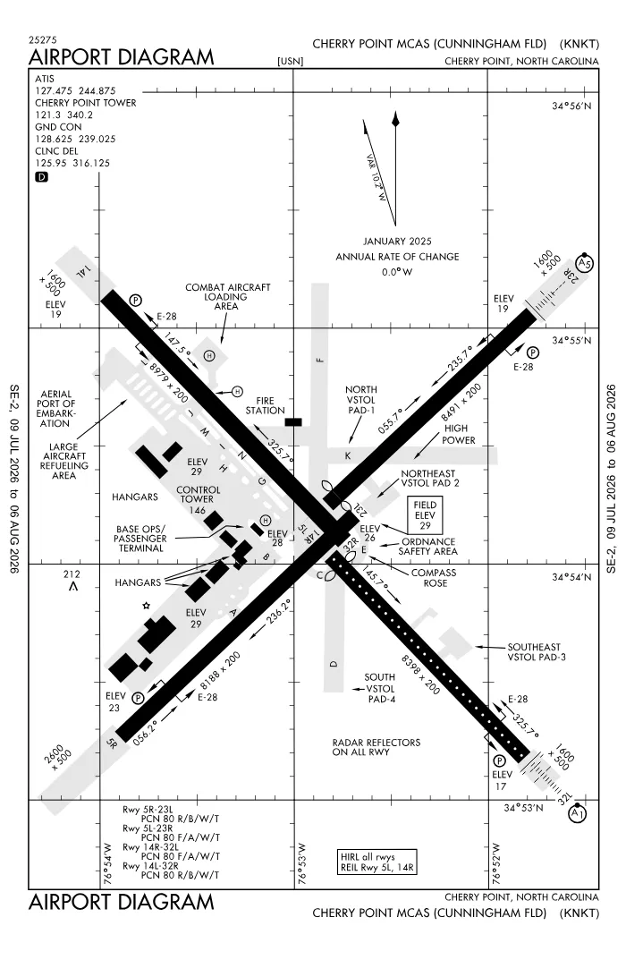 FAA airport diagramView full size ↓
 Nearby now
Loading…
Weather
METAR observed
Loading current weather…
TAF forecast
Loading forecast…
Sun & FAA night2026-09-18 · night begins 07:36 PM
| Event | Local (EDT) | UTC |
|---|---|---|
| Morning civil twilight Loggable night ends | 06:27 AM | 10:27Z |
| Sunrise | 06:52 AM | 10:52Z |
| Sunset | 07:10 PM | 23:10Z |
| Evening civil twilight Loggable night begins | 07:36 PM | 23:36Z |
Plan a flight from KNKT
Past 24 hours category · wind · ceiling · visibility trends
Loading station history…
Density altitude today projected curve · departure window · takeoff roll
Winds aloft NOAA forecast · 3,000 to 53,000 ft
Loading winds aloft…
Full reports: KNKT METAR decoded · KNKT TAF decoded
Advisories
NOTAMs · Loading NOTAMs…
Pilot reports · Loading PIREPs…
Airspace hazards · Checking SIGMETs and G-AIRMETs…
Temporary flight restrictions · Checking for TFRs…
Runways
RWY 14LLEFT traffic
- Heading
- 145° mag · 136° true
- Dimensions
- 8,978 × 200 ft
- TPA
- 1,000 ft MSL (≈1,000 AGL) · standard
- Surface
- Asphalt
- Lights
- 4-light PAPI (left) (3°)
More details — RWY 14L
- Threshold elev
- 19 ft
- Markings
- precision
- Threshold crossing height
- 72 ft
- TDZ elevation
- 26 ft
- Arresting gear
- E28, E5
Pattern side: FAA NASR · TPA standard 1,000 ft AGL (not charted) · layout: FAA runway-end coordinates
| Runway | Length | Your margin |
|---|---|---|
| 14L/32R | 8,978 ft | |
| 05L/23R | 8,489 ft | |
| 14R/32L | 8,397 ft | |
| 05R/23L | 8,189 ft |
Prefer one flat page? Full runway details for KNKT → · New to pattern entries? The 45° entry, explained → · Teaching here? Print the KNKT kneeboard →
Comms & NavAids
Communication frequencies
Before taxi
“Cherry Point”Taxi & takeoff
“Cherry Point”Departure & arrival
“Cherry Point”Departure
“Cherry Point”Also
ATC assigns the exact frequency (in your clearance or on handoff) — which one depends on your SID (departing) or STAR (arriving).
By procedure & sector (14 frequencies)
| Frequency | Used by |
|---|---|
| 126.2 | BASE OPS |
| 239.025 | GND/P |
| 243.0 | EMERG |
| 244.875 | ATIS |
| 268.7 | APCH/P DEP/P ((H)) · DEP/P |
| 299.6 | APCH/P DEP/P IC (EAST 3000 FT & BLW) |
| 305.7 | BASE OPS |
| 316.125 | CD/P |
| 340.2 | LCL/P |
| 343.5 | PMSV METRO |
| 360.2 | LCL/S |
| 360.775 | APCH/P DEP/P IC (EAST ABV 3000 FT) |
| 377.175 | APCH/P DEP/P IC ((W)) |
| 383.4 | OPS (CAMEL BASE) |
Source: FAA NASR (current 28-day cycle).
Instrument landing systems
RWY 23R
| Runway | ILS |
|---|---|
| RWY 23R | ILS/DME · CAT I · LOC 108.9 (NKT) · GS 3.00° |
Source: FAA NASR (current 28-day cycle).
Nearby navigation aids
NKT 112.80 · EWN 113.60 · NCA 115.40
| NavAid | Type | Freq · ch | Range | Radial / Dist magnetic |
|---|---|---|---|---|
| NKT · Cherry Point | TACAN | 112.80 · 75X | — | r263° / 0.3 NM |
| EWN · New Bern | VOR/DME | 113.60 · 83X | Low | r150° / 13.1 NM |
| NCA · New River | TACAN | 115.40 · 101X | — | r075° / 29.9 NM |
Prefer one flat list? All KNKT frequencies →
Charts & procedures
Lowest minimums here: ILS with vertical guidance · VFR sectional →
Airport info
From the field
Do you run KNKT, or an FBO, flight school, or shop on it? Claim your listing to keep fuel, fees, hours, and services current.
Airport information
- ICAO / FAA LID
- KNKT / NKT
- Coordinates
- 34.9032, -76.8808
- Elevation
- 29 ft MSL
- Magnetic variation
- 9W
- Sectional chart
- CHARLOTTE
- Airport use
- Private
- Control tower
- Yes
- Tower hours
- 24 hours
- Airspace
- Class D · CLASS D SVC CONTINUOUS; OTHER TIMES CLASS E
- ARTCC
- WASHINGTON (ZDC)
- Flight service (FSS)
- RALEIGH · 1-800-WX-BRIEF
- NOTAM facility
- NKT
- Attendance
- ALL ALL
- Beacon
- S-white-green (SS-SR)
- Segmented circle
- No
- Activated
- 1943/06
- Distance from city
- 2 NE
Night operations
- Airport lighting
- SEE RMK
- Rotating beacon
- S-white-green · SS-SR
Runway lighting aids — 14L: 4-light PAPI (left) · 23R: 4-light PAPI (left) + MALSR · 32L: 4-light PAPI (left) + ALSF1 · 05R: 4-light PAPI (left).
FAA night windows (civil twilight, loggable night §1.1, currency §61.57) are under Sun & FAA night in the Weather section.
Services fuel · repairs · oxygen · attendance
- Fuel available
- 100LL, Jet (JP-5)
- Bottled oxygen
- NONE
- Bulk oxygen
- HIGH/LOW
Ownership & management 2 contacts
Remarks FAA · 21 notes
General
- ALL ACFT ENROUTE TO CHERRY POINT MCAS RQRG SERVICING CONTACT BASE OPS WITH REQUEST.
- AIRCRAFT STRUCTURAL DE-ICING AVAILABLE.
- PPR WKENDS CTC OPNS DUTY OFFICER; V582-3632/5025.
- LGT: PORTABLE LGT-MOBILE FLOOD LGT.
- A-GEAR: ALL E-28(B) IN RAISED POSN EXC ON LDG RWY. RQR 15 MIN PN.
- JASU: 2 WORKING DAYS PN RQR. 2(GTC-85) 1(NCPP-105)
- FLUID: SP PRESAIR HPOX LOX DE-ICE.
- TRAN ALERT: LTD TRAN MAINT AVBL 1200-2100Z++ MON-FRI. NO LAVATORY SVC AVBL.
- SEE FLIP AP/1 SUPPLEMENTARY ARPT RMK.
- RSTD: MIN 24HR NOTICE PPR ALL TRAN ACFT. CALL BASE OPS DSN 582-2233/4334, C252-466-2233/4334. FLT PLANNING/BASE OPS OPR 24 HR EXCEPT FEDERAL HOLIDAYS, EXP CLOSURE OR REDUCED SVCS PER NOTAM. ALL RWY AND TWY, EXC TWY A AND C, WILL SUPPORT ALL ACFT AT ALL WT.
- CAUTION: EXTV STU JET TRNG (V/STOL) VCNTY ARPT. TRAN ACFT EXP STR-IN FULL STOP LDG ONLY DUR PEAK STU TRNG PERIODS. BIRD HAZ OCT-APR. DRAINAGE DITCHES PARL ALL RWY. WILDLIFE HAZ ON ARPT, ESPECIALLY SS-SR. OBST APRX 200 FT NEAR NKT R-205/3.
- TFC PAT: LDG/TAXI LGT RQR ALL LDG. REDUCED RWY SEPARATION IN EFF FOR USN/USMC ACFT.
- CSTMS/AG/IMG: CSTMS, AG AVBL WITH 24 HR PN. REF FCG FOR DETAILS. ACFT ARR FROM OVERSEAS CTC OPS VIA FONE PATCH 252-466-2233 MIN 2 HR PRIOR TO ARR FOR CSTMS.
- MISC: 24 HR PN RQR OF ALL DV CODES, CTC BASE OPS DSN 582-2233, C252-466-2233. ALL ACFT WITH PAX/CARGO/DV MUST CTC PTD 20 MIN PRIOR TO LDG. ATC TERMINOLOGY - CENTERMAT - IS DEFINED AS THE CNTR OF AFLD WHERE THE FOUR TWYS INT, RATED FOR ALL ACFT WHEEL WEIGHTS.
- TSNT ALERT: PPR MIN 24 HRS IN ADV. TRAN ACFT WITH INERT ORDNANCE, HOT PIT REFUEL LTD TO F18, USAF F15, F16, AND A10 ACFT ONLY IAW CHERRY POINT AIROPS MAN.
- CAUTION: OBSTACLE UNLIT TWR AT NKT200006 549 FT.
- ACFT RESTRICTED FM TAXIING ON TWY K BTN RWY 23R & TEST CELL. TOWING OPERATIONS ONLY.
- MIN 24 HR NTC IF ANTI-ICING/DE-ICING SVC RQR, CTC TRAN ACFT DSN 582-3232, C252-466-3232.
- RWY 05L/23R HAS A Y AMP-3 ALZ PAINTED ON RWY. RWY 14R/32L HAS W AMP-3 ALZ PAINTED ON RWY.
Lighting
- AVBL ONLY DURING HRS OF OPERATION.
Fuel
- FUEL: HOT PIT RFL AVBL.
Embed KNKT weather on your site free widget for schools, clubs & FBOs
Live METAR, flight category, and favored runway for KNKT — paste this into your website's HTML. It updates automatically and stays free.
More widgets — crosswind, E6B, density altitude — on the embed page.
Nearby airports
Loading nearby conditions…
Also nearby: 6NC7 Circle P Farm (private) (9 NM) · NR92 Riviere Ranch (private) (11 NM) · 4NC5 Triple M (private) (13 NM) · 05NC Dead Cow Field (private) (14 NM) · 60NC Star Hill Golf Club (private) (15 NM)
About KNKT
Cherry Point MCAS (Cunningham Field) (NKT · KNKT) is an airport in Cherry Point, NC, at 29 ft MSL. It has 4 runways, the longest 8,978 ft, with a control tower. This page shows live METAR/TAF weather, runway crosswinds, frequencies, navaids, and FAA charts for KNKT, refreshed from the Aviation Weather Center and FAA NASR.
Does KNKT have a control tower?
Yes. Cherry Point MCAS (Cunningham Field) has an operating FAA control tower. See the Comms & NavAids section for tower and ground frequencies.
What is the longest runway at KNKT?
Cherry Point MCAS (Cunningham Field) has 4 runways; the longest is 8,978 ft. See the Runways section for headings, surface, and lighting.
Where is KNKT?
Cherry Point MCAS (Cunningham Field) is in Cherry Point, NC, at an elevation of 29 ft MSL. Coordinates: 34.9032, -76.8808.
More about KNKT
Weather is live from the Aviation Weather Center; airport facility data is from the FAA NASR (28-day cycle). For planning and education only; always verify against official sources. Open KNKT in a full tool: METAR/TAF decoder, crosswind calculator, sun & night times, or the density altitude calculator. Planning from here? Find the nearest airport with fuel or an approach, or check whether an IFR alternate is required.
Something here wrong or out of date? Report a data problem.