
Quantico MCAF (Turner Field) Private
NYG · KNYG · Quantico, VA · Towered · Print kneeboard · Open on the map
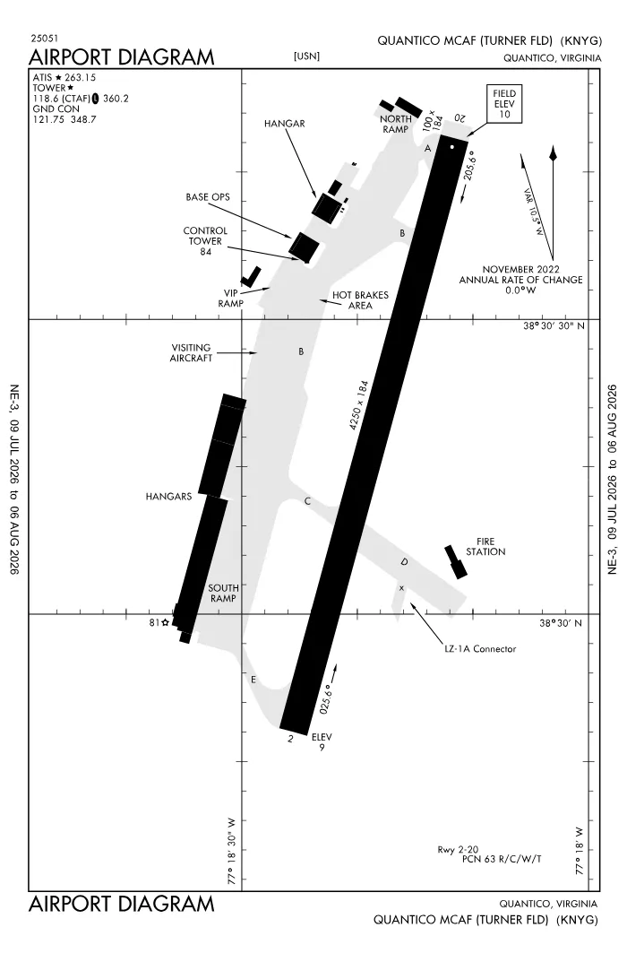 FAA airport diagramView full size ↓
 Nearby now
Loading…
Weather
METAR observed
Loading current weather…
TAF forecast
Loading forecast…
Sun & FAA night2026-09-18 · night begins 07:40 PM
| Event | Local (EDT) | UTC |
|---|---|---|
| Morning civil twilight Loggable night ends | 06:27 AM | 10:27Z |
| Sunrise | 06:53 AM | 10:53Z |
| Sunset | 07:13 PM | 23:13Z |
| Evening civil twilight Loggable night begins | 07:40 PM | 23:40Z |
Plan a flight from KNYG
Past 24 hours category · wind · ceiling · visibility trends
Loading station history…
Density altitude today projected curve · departure window · takeoff roll
Winds aloft NOAA forecast · 3,000 to 53,000 ft
Loading winds aloft…
Full reports: KNYG METAR decoded · KNYG TAF decoded
Advisories
NOTAMs · Loading NOTAMs…
Pilot reports · Loading PIREPs…
Airspace hazards · Checking SIGMETs and G-AIRMETs…
Temporary flight restrictions · Checking for TFRs…
Runways
RWY 20LEFT traffic
- Heading
- 206° mag · 195° true
- Dimensions
- 4,250 × 184 ft
- TPA
- 1,000 ft MSL (≈1,000 AGL) · standard
- Surface
- PEM
- CTAF
- 118.6
More details — RWY 20
- Threshold elev
- 10 ft
- Markings
- precision
- TDZ elevation
- 10 ft
- End lights
- REIL
Pattern side: FAA NASR · TPA standard 1,000 ft AGL (not charted) · layout: FAA runway-end coordinates
| Runway | Length | Your margin |
|---|---|---|
| 02/20 | 4,250 ft |
Prefer one flat page? Full runway details for KNYG → · New to pattern entries? The 45° entry, explained → · Teaching here? Print the KNYG kneeboard →
Comms & NavAids
Communication frequencies
Taxi & takeoff
“Quantico”Departure & arrival
“Potomac”Also
ATC assigns the exact frequency (in your clearance or on handoff) — which one depends on your SID (departing) or STAR (arriving).
By procedure & sector (11 frequencies)
| Frequency | Used by |
|---|---|
| 120.45 | TIKEE STAR |
| 126.75 | TRSTN STAR |
| 128.525 | HYPER STAR (091-240) · PRTZL STAR (091-240) · WAYNZ STAR (091-240) |
| 243.0 | EMERG |
| 263.15 | ATIS |
| 290.375 | APCH/P DEP/P |
| 306.925 | APCH/S DEP/S (WHEN NYG TWR CLSD) · HYPER STAR (091-330) · PRTZL STAR (091-330) · TIKEE STAR · WAYNZ STAR (091-330) |
| 307.2 | TRSTN STAR |
| 340.2 | GND/P |
| 355.3 | BASE OPS · PMSV METRO |
| 360.2 | LCL/P |
Source: FAA NASR (current 28-day cycle).
Instrument landing systems
RWY 02
| Runway | ILS |
|---|---|
| RWY 02 | ILS/DME · CAT I · LOC 108.3 (NYG) · GS 3.00° |
Source: FAA NASR (current 28-day cycle).
Nearby navigation aids
BRV 114.50 · DCA 111.00 · AML 113.50 · +3
| NavAid | Type | Freq · ch | Range | Radial / Dist magnetic |
|---|---|---|---|---|
| BRV · Brooke | VORTAC | 114.50 · 92X | Low | r022° / 10.2 NM |
| DCA · Washington | VOR/DME | 111.00 · 47X | Low | r219° / 24.9 NM |
| AML · Armel | VOR/DME | 113.50 · 82X | Low | r172° / 27.1 NM |
| ADW · Andrews | VORTAC | 113.10 · 78X | Low | r238° / 27.6 NM |
| CSN · Casanova | VORTAC | 116.30 · 110X | High | r113° / 27.6 NM |
| OTT · Nottingham | TACAN | 113.70 · 84X | — | r255° / 29 NM |
Prefer one flat list? All KNYG frequencies →
Charts & procedures
Lowest minimums here: ILS with vertical guidance · VFR sectional →
Airport info
From the field
Do you run KNYG, or an FBO, flight school, or shop on it? Claim your listing to keep fuel, fees, hours, and services current.
Airport information
- ICAO / FAA LID
- KNYG / NYG
- Coordinates
- 38.5036, -77.3050
- Elevation
- 10 ft MSL
- Magnetic variation
- 11W
- Sectional chart
- WASHINGTON
- Airport use
- Private
- Control tower
- Yes
- Tower hours
- 1300-0200Z++ MON-THU; 1300-2200Z++ FRI; OPR SAT, SUN, AND HOL BY NOTAM ONLY.
- Airspace
- Class D · CLASS D SVC 1300-0200Z++ MON-THU, 1300-2200Z++ FRI, OPR SAT, SUN, AND HOL BY NOTAM ONLY; OTHER TIMES CLASS G
- ARTCC
- WASHINGTON (ZDC)
- Flight service (FSS)
- LEESBURG · 1-800-WX-BRIEF
- NOTAM facility
- DCA
- Attendance
- MON-THU 1300-0000Z++; FRI 1300-2200Z++; SAT/SUN/HOLS CLSD
- Beacon
- S-white-green (SS-SR)
- Segmented circle
- No
- Activated
- 1944/01
- Distance from city
- 1 S
Night operations
- Airport lighting
- SEE RMK
- Rotating beacon
- S-white-green · SS-SR
- Pilot-controlled lighting
- WHEN TWR CLSD ACTVT REILS RWY 02 & 20; PAPI RWY 02; HIRL RWY 02/20; CL RWY 02; TWY LGTS - CTAF. TO ACTVT & INCR INTS CMSND KEY 118.6 7 TIMES HIGH, 5 TIMES MED, 3 TIMES LOW. — Chart Supplement ↗
Runway lighting aids — 02: 4-light PAPI (left).
FAA night windows (civil twilight, loggable night §1.1, currency §61.57) are under Sun & FAA night in the Weather section.
Services fuel · repairs · oxygen · attendance
- Fuel available
- Jet A-1 (additive)
- Bottled oxygen
- NONE
- Bulk oxygen
- HIGH
Ownership & management 2 contacts
Remarks FAA · 21 notes
General
- FUEL: A++; LTD SUP. EXP NO MORE THAN 10K OVER PPR.
- TRAN ALERT: NO TRAN MAINT AVBL. REQUIRE QUALIFIED CREW MEMBER TO ASSIST IN COLD REFUELING.
- BIRD HAZ VCNTY RWY 02-20 SR-SS. HVY MIGRATORY BIRD ACT OCT-MAR, HVY OSPREY ACT MAR-JUL, HVY EAGLE ACT DEC-JUL.
- NS ABTMT: THE AREA IN AND ARND THE QUANTICO CLASS D AIRSPACE IS NOISE SENSITIVE. COPTER TRANSIT QUANTICO CLASS D AIRSPACE AT OR ABV 1000 FT AGL.
- MISC: CAT II CRASH/FIRE RESCUE SVC.
- REMARKS: MCAF QUANTICO HAS NO PROVISIONS FOR SPACE A PASSENGERS. SPACE A PASSENGERS CANNOT BE ON-LOADED OR OFF-LOADED DUE TO SECURITY ISSUES.
- MISC: MCAF QUANTICO AND R-6608 LIE WITH THE WASHINGTON ADIZ. PILOTS MUST ADHERE TO ADIZ RPRTG PROCS IN BOTH THESE AREAS. TWY A LTD TO R/W DALGT VFR ONLY.
- CSTMS/AG/IMG: NOT AVBL.
- RSTD: ALL TRAN ACFT 24 HR PPR; BASE OPS DSN 278-2085/1459, OR C703-784-2085/1459. AFTER 2200Z++ AND ON WEEKEND CALL DSN 378-0920, C703-432-0920 OR C703-675-3623 FOR PPR. NO TRAN ACFT OPS OUTSIDE PUBL HR WO MCAF QUANTICO CO APVL.
- CAUTION: NO MANDATORY RWY VFR HOLD POSITION SIGNS CO-LOCATED W/MARKINGS ON TWYS A, B, AND D. RWY 02 OVRN 100 FT. RWY 20 NO OVRN.
- FOR CD WHEN NYG ATCT/APCH ARE CLSD CTC POTOMAC APCH AT 866-709-4993.
- RWY: NO 180 DEG TURNS ON RWY ASP.
- MISC: 180 DEG TURNS ONLY ON CONC EOR.
- MISC: NO STAGGERED ACFT DEVS FR RCL.
- CAUTION: TWY D SFC CONSISTS OF AM-2 ALUMINUM MATTING WITH NON-SKID ALL WX COATING; NO EDGE LGTNG ON TWY D. TWY B EDGE LGT NON STD FIRST 100 FT AT RWY ENTERANCE/EXIT (NORTH EDGE) LOCATED 20 FT FROM USABLE PAVEMENT.
- C-17 LANDING ZONE MARKED BUT NOT CERTIFIED. ASSAULT LDGS NA.
- MISC: AUTOMATED WEATHER BROADCAST AVBL DURING HOUR OF AIRFIELD CLOSURE ON 355.3.
Runways
- RWY 02/20 GROOVED FULL LENGTH.
Lighting
- WHEN TWR CLSD ACTVT REILS RWY 02 & 20; PAPI RWY 02; HIRL RWY 02/20; CL RWY 02; TWY LGTS - CTAF. TO ACTVT & INCR INTS CMSND KEY 118.6 7 TIMES HIGH, 5 TIMES MED, 3 TIMES LOW.
- FIRST 1000 FT.
Contact
- ARPT MANAGER 703-784-1449.
Embed KNYG weather on your site free widget for schools, clubs & FBOs
Live METAR, flight category, and favored runway for KNYG — paste this into your website's HTML. It updates automatically and stays free.
More widgets — crosswind, E6B, density altitude — on the embed page.
Nearby airports
Loading nearby conditions…
Also nearby: 5VA5 Chimney View (private) (6 NM) · MD55 Holly Springs Farm (private) (8 NM) · MD05 Finagin Airfield (private) (9 NM) · 8MD6 Burgess Field (private) (10 NM) · VA42 Dogwood Airpark (private) (11 NM)
About KNYG
Quantico MCAF (Turner Field) (NYG · KNYG) is an airport in Quantico, VA, at 10 ft MSL. It has 1 runway, the longest 4,250 ft, with a control tower. This page shows live METAR/TAF weather, runway crosswinds, frequencies, navaids, and FAA charts for KNYG, refreshed from the Aviation Weather Center and FAA NASR.
Does KNYG have a control tower?
Yes. Quantico MCAF (Turner Field) has an operating FAA control tower. See the Comms & NavAids section for tower and ground frequencies.
What is the longest runway at KNYG?
Quantico MCAF (Turner Field) has 1 runway; the longest is 4,250 ft. See the Runways section for headings, surface, and lighting.
Where is KNYG?
Quantico MCAF (Turner Field) is in Quantico, VA, at an elevation of 10 ft MSL. Coordinates: 38.5036, -77.3050.
More about KNYG
Weather is live from the Aviation Weather Center; airport facility data is from the FAA NASR (28-day cycle). For planning and education only; always verify against official sources. Open KNYG in a full tool: METAR/TAF decoder, crosswind calculator, sun & night times, or the density altitude calculator. Planning from here? Find the nearest airport with fuel or an approach, or check whether an IFR alternate is required.
Something here wrong or out of date? Report a data problem.