
Mc Ghee Tyson
TYS · KTYS · Knoxville, TN · Towered · Print kneeboard · Open on the map
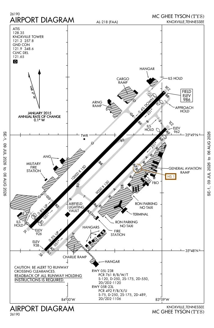 FAA airport diagramView full size ↓
 Nearby now
Loading…
Weather
METAR observed
Loading current weather…
TAF forecast
Loading forecast…
Sun & FAA night2026-09-18 · night begins 08:05 PM
| Event | Local (EDT) | UTC |
|---|---|---|
| Morning civil twilight Loggable night ends | 06:55 AM | 10:55Z |
| Sunrise | 07:21 AM | 11:21Z |
| Sunset | 07:39 PM | 23:39Z |
| Evening civil twilight Loggable night begins | 08:05 PM | 00:05Z |
Plan a flight from KTYS
Past 24 hours category · wind · ceiling · visibility trends
Loading station history…
Density altitude today projected curve · departure window · takeoff roll
Winds aloft NOAA forecast · 3,000 to 53,000 ft
Loading winds aloft…
Full reports: KTYS METAR decoded · KTYS TAF decoded
Advisories
NOTAMs · Loading NOTAMs…
Pilot reports · Loading PIREPs…
Airspace hazards · Checking SIGMETs and G-AIRMETs…
Temporary flight restrictions · Checking for TFRs…
Runways
RWY 05LLEFT traffic
- Heading
- 051° mag · 045° true
- Dimensions
- 10,000 × 150 ft
- TPA
- 2,000 ft MSL (≈1,000 AGL) · standard
- Surface
- Concrete
- Lights
- 4-light PAPI (left) (3°) + MALSR
- ILS
- ILS · CAT I · LOC 110.3 (TYS) · GS 3.00°
- Displaced thr
- 490 ft
- CTAF
- 122.95
More details — RWY 05L
- Threshold elev
- 926 ft
- Markings
- precision
- Threshold crossing height
- 55 ft
- TDZ elevation
- 953 ft
- Declared TORA/TODA/ASDA/LDA
- 10,000 / 10,000 / 10,000 / 9,508 ft
- End lights
- centerline
Pattern side + displaced threshold: FAA NASR · TPA standard 1,000 ft AGL (not charted) · layout: FAA runway-end coordinates
| Runway | Length | Your margin |
|---|---|---|
| 05L/23R | 10,000 ft | |
| 05R/23L | 9,000 ft |
Prefer one flat page? Full runway details for KTYS → · New to pattern entries? The 45° entry, explained → · Teaching here? Print the KTYS kneeboard →
Comms & NavAids
Communication frequencies
Before taxi
“Knoxville”Taxi & takeoff
“Knoxville”Departure & arrival
“Knoxville”Also
ATC assigns the exact frequency (in your clearance or on handoff) — which one depends on your SID (departing) or STAR (arriving).
By procedure & sector (12 frequencies)
| Frequency | Used by |
|---|---|
| 49.95 | ARNG OPS |
| 118.0 | CLASS C (051-229) |
| 123.9 | CLASS C (230-050) |
| 143.8 | ANG OPS |
| 149.8 | ARNG OPS |
| 243.0 | EMERG |
| 257.8 | LCL/P |
| 303.25 | ANG OPS (SODA CAN CON) |
| 348.6 | GND/P |
| 353.6 | APCH/P DEP/P (230-050) · CLASS C (230-050) |
| 360.8 | APCH/P DEP/P IC (051-229) · CLASS C (051-229) |
| 373.9 | ARNG OPS |
Source: FAA NASR (current 28-day cycle).
Instrument landing systems
RWY 05L · RWY 23R · RWY 23L
| Runway | ILS |
|---|---|
| RWY 05L | ILS · CAT I · LOC 110.3 (TYS) · GS 3.00° |
| RWY 23R | ILS · CAT II · LOC 111.7 (BUI) · GS 3.00° |
| RWY 23L | ILS/DME · CAT I · LOC 110.75 (OXH) · GS 3.00° |
Source: FAA NASR (current 28-day cycle).
Nearby navigation aids
VXV 116.40
| NavAid | Type | Freq · ch | Range | Radial / Dist magnetic |
|---|---|---|---|---|
| VXV · Volunteer | VORTAC | 116.40 · 111X | High | r224° / 7.4 NM |
Prefer one flat list? All KTYS frequencies →
Charts & procedures
Lowest minimums here: ILS with vertical guidance · VFR sectional →
Airport info
From the field
Do you run KTYS, or an FBO, flight school, or shop on it? Claim your listing to keep fuel, fees, hours, and services current.
Airport information
- ICAO / FAA LID
- KTYS / TYS
- Coordinates
- 35.8111, -83.9941
- Elevation
- 986 ft MSL
- Magnetic variation
- 6W
- Sectional chart
- ATLANTA
- Airport use
- Public
- Control tower
- Yes
- Tower hours
- 24 hours
- Airspace
- Class C
- Weather station
- ASOS · 128.35 · ☎ 423-219-5043
- ARTCC
- ATLANTA (ZTL)
- Flight service (FSS)
- NASHVILLE · 122.2 · 1-800-WX-BRIEF
- NOTAM facility
- TYS
- Attendance
- ALL ALL
- Beacon
- white-green (SS-SR)
- Segmented circle
- Yes
- Wind indicator
- lighted
- FAR 139 class
- I C
- Activated
- 1970/01
- Distance from city
- 10 S
Night operations
- Airport lighting
- SS-SR
- Rotating beacon
- white-green · SS-SR
- Pilot-controlled lighting
- Usually keyed on CTAF 122.95 — confirm the click sequence in the Chart Supplement ↗
Runway lighting aids — 05L: 4-light PAPI (left) + MALSR · 23R: 4-light PAPI (left) + ALSF2 · 05R: 4-light PAPI (left) · 23L: 4-light PAPI (left).
FAA night windows (civil twilight, loggable night §1.1, currency §61.57) are under Sun & FAA night in the Weather section.
Services fuel · repairs · oxygen · attendance
- Fuel available
- 100LL, Jet A, A++
- Bulk oxygen
- HIGH
- Airframe service
- MAJOR
- Powerplant service
- MAJOR
- Parking
- tiedowns, hangars
- Other services
- Air freight, Avionics, Cargo, Charter, Instruction, Rental, Aircraft sales, Survey
Ownership & management 2 contacts
Remarks FAA · 19 notes
General
- BIRDS ON & INVOF OF ARPT; INCRD OCT-APR.
- CIVIL PPR TO USE TWYS G1, G2, G3 & G SOUTH OF TWY G4 - ANG 865-336-4371.
- RWY 23L & 23R DEP MNTN RWY HDG UNTIL PASSING RESIDENTIAL AREA S OF EXTDD CNTRLN UNLESS INSTRD BY ATC.
- WIDE BODY USE CTN TURNING ONTO TWY A FM RAMP 4, 5 & 6.
- CTN: PTN OF TWY A NEAR RWY 05R APCH END NOT VSB FM TWR.
- ANG OPS CTC SODA CTL 303.025.
- ANG: COMD POST H24 - D266-4371/ C865-336-4371. AMGR DOES NOT ISSUE OR STORE COMSEC FOR TSNT. TMPRY STOR OF CLASSIFIED MATERIALS UP TO TOP SECRET AT COMD POST.
- ANG: PPR 24 HR PN RQR, LTD TO OFFL BUS ONLY, CTC AIRFIELD MGMT DSN 266-4404/4419, C865-336-4404/4419. OPR 0700-1630 MON-FRI (CLSD EV OTH MON), FAC CLSD SAT, SUN AND HOL.
- CTN: HOLD SHORT LINE FOR RWY 23L SLIGHTLY N OF TWY A-8.
- ANG: ARNG RAMP NOT SUITABLE FOR AMC ACFT EXC C-21.
- CSTMS/AG/IMG: MIL CUSTOMS 72 HR PPR.
- RWY 5L/23R & 5R/23L WT BRG CPTY FOR 2S LNDG GEAR IS 175.
- ACFT DESIGN GROUP V OR LRGR USING TRML RAMP RQR PPR 865-342-3177.
- GA RAMP NOT AVBL FOR ACR OPS.
- ARNG: BASEOPS OPR 0700-1630 MON-FRI (CLSD EV OTH MON), FAC CLSD SAT, SUN AND HOL. C629-332-8765/8809, DSN 312-683-8765/8809.
- RWY 05R/23L DIST RMNG SIGNS ARE REMOVED.
Runways
- PCR VALUE: 761/R/B/W/T
- PCR VALUE: 492/F/B/X/U
Fuel
- MIL CONTR FUEL AVBL.
Embed KTYS weather on your site free widget for schools, clubs & FBOs
Live METAR, flight category, and favored runway for KTYS — paste this into your website's HTML. It updates automatically and stays free.
More widgets — crosswind, E6B, density altitude — on the embed page.
Nearby airports
Loading nearby conditions…
Also nearby: 44TN Stone Field (private) (4 NM) · TN98 Sky Ranch (private) (5 NM) · TN87 Montvale Airpark (private) (7 NM) · 8TN3 Raby Airpark (private) (9 NM) · 3TN8 Seabrook (private) (10 NM) · 5TN4 McGraw's Backyard (private) (10 NM)
Destination
In the terminal
Airside, past security. Not reachable from the GA ramp without clearing screening, so treat it as terminal food rather than a fly in stop.
Courtesy car? Check airportcourtesycars.com
Places powered by Google. Only what is on the airport itself, for now. Open a place for hours, reviews and directions.
About KTYS
Mc Ghee Tyson (TYS · KTYS) is an airport in Knoxville, TN, at 986 ft MSL. It has 2 runways, the longest 10,000 ft, with a control tower. This page shows live METAR/TAF weather, runway crosswinds, frequencies, navaids, and FAA charts for KTYS, refreshed from the Aviation Weather Center and FAA NASR.
Does KTYS have a control tower?
Yes. Mc Ghee Tyson has an operating FAA control tower. See the Comms & NavAids section for tower and ground frequencies.
What is the longest runway at KTYS?
Mc Ghee Tyson has 2 runways; the longest is 10,000 ft. See the Runways section for headings, surface, and lighting.
Where is KTYS?
Mc Ghee Tyson is in Knoxville, TN, at an elevation of 986 ft MSL. Coordinates: 35.8111, -83.9941.
More about KTYS
Weather is live from the Aviation Weather Center; airport facility data is from the FAA NASR (28-day cycle). For planning and education only; always verify against official sources. Open KTYS in a full tool: METAR/TAF decoder, crosswind calculator, sun & night times, or the density altitude calculator. Planning from here? Find the nearest airport with fuel or an approach, or check whether an IFR alternate is required.
Something here wrong or out of date? Report a data problem.