
Mountain Home AFB Private
MUO · KMUO · Mountain Home, ID · Towered · Print kneeboard · Open on the map
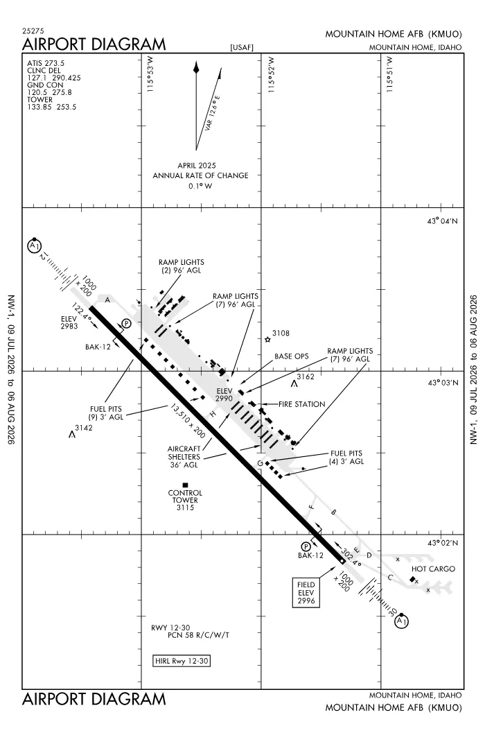 FAA airport diagramView full size ↓
 Nearby now
Loading…
Weather
METAR observed
Loading current weather…
TAF forecast
Loading forecast…
Sun & FAA night2026-09-18 · night begins 08:17 PM
| Event | Local (MDT) | UTC |
|---|---|---|
| Morning civil twilight Loggable night ends | 06:58 AM | 12:58Z |
| Sunrise | 07:26 AM | 13:26Z |
| Sunset | 07:48 PM | 01:48Z |
| Evening civil twilight Loggable night begins | 08:17 PM | 02:17Z |
Plan a flight from KMUO
Past 24 hours category · wind · ceiling · visibility trends
Loading station history…
Density altitude today projected curve · departure window · takeoff roll
Computing today's density altitude…
Winds aloft NOAA forecast · 3,000 to 53,000 ft
Loading winds aloft…
Full reports: KMUO METAR decoded · KMUO TAF decoded
Advisories
NOTAMs · Loading NOTAMs…
Pilot reports · Loading PIREPs…
Airspace hazards · Checking SIGMETs and G-AIRMETs…
Temporary flight restrictions · Checking for TFRs…
Runways
RWY 12LEFT traffic
- Heading
- 122° mag · 135° true
- Dimensions
- 13,510 × 200 ft
- TPA
- 4,000 ft MSL (≈1,000 AGL) · standard
- Surface
- PEM
- Lights
- 4-light PAPI (left) (2.5°) + ALSF1
- ILS
- ILS · CAT I · LOC 110.3 (MUO) · GS 2.50°
More details — RWY 12
- Threshold elev
- 2,983 ft
- Markings
- precision
- Threshold crossing height
- 40 ft
- TDZ elevation
- 2,986 ft
- Arresting gear
- BAK-12B
Pattern side: FAA NASR · TPA standard 1,000 ft AGL (not charted) · layout: FAA runway-end coordinates
| Runway | Length | Your margin |
|---|---|---|
| 12/30 | 13,510 ft |
Prefer one flat page? Full runway details for KMUO → · New to pattern entries? The 45° entry, explained → · Teaching here? Print the KMUO kneeboard →
Comms & NavAids
Communication frequencies
Before taxi
“Mountain Home”Taxi & takeoff
“Mountain Home”Arrival
“Mountain Home”Also
ATC assigns the exact frequency (in your clearance or on handoff) — which one depends on your SID (departing) or STAR (arriving).
By procedure & sector (11 frequencies)
| Frequency | Used by |
|---|---|
| 139.3 | PTD |
| 243.0 | EMERG |
| 253.5 | LCL/P |
| 259.1 | APCH/P |
| 273.5 | ATIS |
| 275.8 | GND/P |
| 290.425 | CD/P |
| 311.0 | COMD POST |
| 324.1 | PMSV METRO |
| 341.8 | PTD |
| 369.2 | DEP/P |
Source: FAA NASR (current 28-day cycle).
Instrument landing systems
RWY 12 · RWY 30
| Runway | ILS |
|---|---|
| RWY 12 | ILS · CAT I · LOC 110.3 (MUO) · GS 2.50° |
| RWY 30 | ILS · CAT I · LOC 111.7 (BRN) · GS 2.50° |
Source: FAA NASR (current 28-day cycle).
Nearby navigation aids
MUO 114.00 · BOI 113.30
| NavAid | Type | Freq · ch | Range | Radial / Dist magnetic |
|---|---|---|---|---|
| MUO · Mountain Home | TACAN | 114.00 · 87X | — | r018° / 0.2 NM |
| BOI · Boise | VORTAC | 113.30 · 80X | High | r138° / 33.6 NM |
Prefer one flat list? All KMUO frequencies →
Charts & procedures
Lowest minimums here: ILS with vertical guidance · VFR sectional →
Airport info
From the field
Do you run KMUO, or an FBO, flight school, or shop on it? Claim your listing to keep fuel, fees, hours, and services current.
Airport information
- ICAO / FAA LID
- KMUO / MUO
- Coordinates
- 43.0436, -115.8724
- Elevation
- 2,996 ft MSL
- Magnetic variation
- 13E
- Sectional chart
- SALT LAKE CITY
- Airport use
- Private
- Control tower
- Yes
- Tower hours
- 1400 - 0700Z++ MON - THU; 1400 - 0100Z++ FRI; 1500 - 2300Z++ SAT - SUN; CLSD HOL.
- Airspace
- Class D · CLASS D SVC 1400-0700Z++ MON-THU, 1400-0100Z++ FRI, 1500-2300Z++ SAT-SUN, CLSD HOL; OTHER TIMES CLASS E
- ARTCC
- SALT LAKE CITY (ZLC)
- Flight service (FSS)
- BOISE · 122.6 · 1-800-WX-BRIEF
- NOTAM facility
- MUO
- Attendance
- MON-THU 1400-1700Z++
- Beacon
- white-green (SS-SR)
- Segmented circle
- No
- Wind indicator
- yes
- Activated
- 1944/02
- Distance from city
- 10 SW
Night operations
- Airport lighting
- SS-SR
- Rotating beacon
- white-green · SS-SR
Runway lighting aids — 12: 4-light PAPI (left) + ALSF1 · 30: 4-light PAPI (left) + ALSF1.
FAA night windows (civil twilight, loggable night §1.1, currency §61.57) are under Sun & FAA night in the Weather section.
Services fuel · repairs · oxygen · attendance
- Fuel available
- A++
- Bulk oxygen
- HIGH/LOW
- Parking
- hangars
- Other services
- Cargo
Ownership & management 2 contacts
Remarks FAA · 30 notes
General
- A-GEAR BAK-12B IN RAISED POSN; RQR 1 HR PN FOR REMOVAL.
- JASU: 2(AM32A-60)
- OIL: O-148-156 JOAP.
- TRANS ALERT: 1400-0700Z++ MON-THU; 1400-0100Z++ FRI; CLSD WKEND AND HOL. NO INTL LAV CAP.
- RSTD: PPR EXC VIP CODE 6 OR ABV, AIREVAC & SAAM; REQ VIP, AIREVAC & SAAM OBTAIN PPR NMBR FOR PLANNING; MIN 24 HR NOTICE & NO MORE THAN 7 DAYS PRIOR RQR. CSTMS PROVIDED BY KBOI. ACFT RQR CSTMS MUST COORD FOR PPR NO LATER THAN 72 HR PRIOR WITH AFLD MGMT. CHANGES WI WINDOW MUST BE COMMUNICATED.
- WATERFOWL HAZ INVOF ARPT.
- TFC PAT: OVHD/FTR RECTANGULAR 4800 FT, LGT ACFT/COPTER 3800 FT. ALL DEP MAINT AT OR BLW 4300 FT TIL DEP END. CARGO RECTANGULAR AT 4300 FT.
- NOISE ABATMENT: QUIET HR 0530-1300Z++.
- CARRY DRAG CHUTES TO PRK OR ADVS ATCT.
- MISC: ACC ACFT EXP RDCD RWY SEPN; NON RSRS PTCPG ACC ACFT ADVISE ATCT ON INITIAL CTC.
- ACC COMD POST: 311.0 321.0 15091 REMARKS (HAVE QUICK TIMING AVBL 381.3) PRIM: GUNFIGHTER CTL; ALT: RAYMOND 27.
- CTN: EOR TAXILINES FOR WINGSPAN OF 43 FT OR LESS.
- MISC: SUBJECT TO SHORT NOTICE CLOSURE.
- MISC: WX AN/FMQ-19 AUTO OBS SYS; HUMAN OBS AUGMENTED DURG OPR HR - D728-6304/C208-828-6304.
- RSTD: ADHERE TO ETA +/- 30 MIN OR PPR INVALID. TSNT CREW ORDERS RQR ON ARR FOR SCTY FORCES - AMGR D728-2222/C208-828-2222.
- MISC: OBS SFC VIS LTD FM 310-090.
- FLUID: DE-ICE.
- MISC: EMERG ATCT & WX SVC AFT HR - COMD POST D728-5800/C208-828-5800; EXP 30 MIN DELAY.
- FOR CD IF UNA TO CTC ON FSS FREQ, CTC SALT LAKE ARTCC AT 801-320-2568.
- RSTD: AERODROME VERT TKOF/LDG NA.
- RSTD: COMSEC AVBL AT COMD POST.
- CTN: WHEN FIGHTER ACFT ARE UTILIZING EOR'S: TWY A EOR RSTRD TO ACFT WITH 134 FT WINGSPAN OR LESS, TWY E & F EOR'S RSTRD TO ACFT WITH 80 FT WINGSPAN OR LESS.
- RSTD: NO HYDRAZINE RESPONSE AND OR EPU CAPABILITIES ON STATION, 300 FT CORDON WILL BE ESTABLISHED, ACFT UNIT WILL COORD A RESPONSE TEAM TO SAFE THE ACFT.
Runways
- FULL LEN OF RWY 12/30 GRVD.
- MKD 150 FT WIDE.
- NONSTD OVRN LEN 986 FT.
- NONSTD OVRN LEN 985 FT.
- FIRST 1280 FT BOTH ENDS CONC; MID 10940 FT ASPH/CONC.
Attendance
- CLSD SAT, SUN & HOL.
- 1400- 0100Z++ FRI.
Embed KMUO weather on your site free widget for schools, clubs & FBOs
Live METAR, flight category, and favored runway for KMUO — paste this into your website's HTML. It updates automatically and stays free.
More widgets — crosswind, E6B, density altitude — on the embed page.
Nearby airports
Loading nearby conditions…
Also nearby: U76 Mountain Home Municipal (8 NM) · ID42 Poplar Point (private) (9 NM) · 0ID3 Coyote Run (private) (9 NM) · ID26 P And R Field (private) (12 NM) · 1ID4 Oasis Airpark (private) (16 NM) · U89 Glenns Ferry Municipal (25 NM)
About KMUO
Mountain Home AFB (MUO · KMUO) is an airport in Mountain Home, ID, at 2,996 ft MSL. It has 1 runway, the longest 13,510 ft, with a control tower. This page shows live METAR/TAF weather, runway crosswinds, frequencies, navaids, and FAA charts for KMUO, refreshed from the Aviation Weather Center and FAA NASR.
Does KMUO have a control tower?
Yes. Mountain Home AFB has an operating FAA control tower. See the Comms & NavAids section for tower and ground frequencies.
What is the longest runway at KMUO?
Mountain Home AFB has 1 runway; the longest is 13,510 ft. See the Runways section for headings, surface, and lighting.
Where is KMUO?
Mountain Home AFB is in Mountain Home, ID, at an elevation of 2,996 ft MSL. Coordinates: 43.0436, -115.8724.
More about KMUO
Weather is live from the Aviation Weather Center; airport facility data is from the FAA NASR (28-day cycle). For planning and education only; always verify against official sources. Open KMUO in a full tool: METAR/TAF decoder, crosswind calculator, sun & night times, or the density altitude calculator. Planning from here? Find the nearest airport with fuel or an approach, or check whether an IFR alternate is required.
Something here wrong or out of date? Report a data problem.