
Selfridge ANGB Private
MTC · KMTC · Mount Clemens, MI · Towered · Print kneeboard · Open on the map
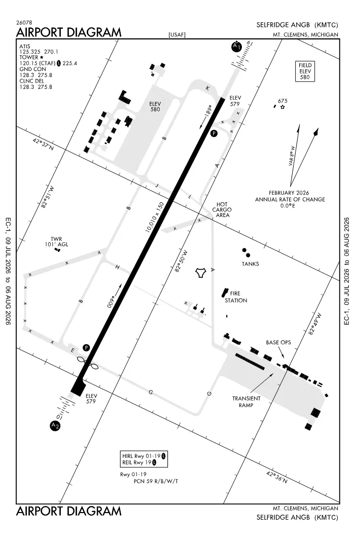 FAA airport diagramView full size ↓
 Nearby now
Loading…
Weather
METAR observed
Loading current weather…
TAF forecast
Loading forecast…
Sun & FAA night2026-09-18 · night begins 08:04 PM
| Event | Local (EDT) | UTC |
|---|---|---|
| Morning civil twilight Loggable night ends | 06:46 AM | 10:46Z |
| Sunrise | 07:14 AM | 11:14Z |
| Sunset | 07:36 PM | 23:36Z |
| Evening civil twilight Loggable night begins | 08:04 PM | 00:04Z |
Plan a flight from KMTC
Past 24 hours category · wind · ceiling · visibility trends
Loading station history…
Density altitude today projected curve · departure window · takeoff roll
Winds aloft NOAA forecast · 3,000 to 53,000 ft
Loading winds aloft…
Full reports: KMTC METAR decoded · KMTC TAF decoded
Advisories
NOTAMs · Loading NOTAMs…
Pilot reports · Loading PIREPs…
Airspace hazards · Checking SIGMETs and G-AIRMETs…
Temporary flight restrictions · Checking for TFRs…
Runways
RWY 19RIGHT trafficRP · charted
- Heading
- 187° mag · 181° true
- Dimensions
- 10,010 × 150 ft
- TPA
- 1,600 ft MSL (≈1,000 AGL) · standard
- Surface
- PEM
- Lights
- 4-light PAPI (left) (3°) + ALSF1
- ILS
- ILS · CAT I · LOC 110.1 (MTC) · GS 3.00°
More details — RWY 19
- Threshold elev
- 579 ft
- Markings
- precision
- Threshold crossing height
- 51 ft
- TDZ elevation
- 579 ft
- End lights
- REIL
Pattern side: FAA NASR · TPA standard 1,000 ft AGL (not charted) · layout: FAA runway-end coordinates
| Runway | Length | Your margin |
|---|---|---|
| 01/19 | 10,010 ft |
Prefer one flat page? Full runway details for KMTC → · New to pattern entries? The 45° entry, explained → · Teaching here? Print the KMTC kneeboard →
Comms & NavAids
Communication frequencies
Before taxi
“Selfridge”Taxi & takeoff
“Selfridge”Departure & arrival
“Selfridge”Also
ATC assigns the exact frequency (in your clearance or on handoff) — which one depends on your SID (departing) or STAR (arriving).
By procedure & sector (22 frequencies)
| Frequency | Used by |
|---|---|
| 119.6 | BARII DP · CCOBB DP · CLVIN DP · GGIBY DP · HHOWE DP · KAYLN DP · LIDDS DP · MIGGY DP · PAVYL DP · SNDRS DP · ZETTR DP |
| 123.1 | MEDEVAC |
| 157.075 | CG OPS (USCG DETROIT AIR) |
| 225.4 | LCL/P |
| 243.0 | EMERG |
| 259.3 | SFA |
| 262.8 | MEDEVAC |
| 270.1 | ATIS |
| 275.8 | CD/P · GND/P |
| 290.9 | SFA |
| 311.0 | COMD POST (WING COMD POST QUARTER BACK CTL) |
| 318.6 | NAF OPS |
| 321.0 | COMD POST (WING COMD POST QUARTER BACK CTL) |
| 345.0 | CG OPS (USCG DETROIT AIR) |
| 349.4 | COMD POST (WING CMD POST) |
| 363.2 | APCH/P DEP/P |
| 372.2 | PTD |
| 381.0 | MEDEVAC |
| 381.8 | CG OPS (USCG DETROIT AIR) |
| 388.2 | SFA |
| 391.9 | APCH/P DEP/P IC |
| 5692.0 | CG OPS (USCG DETROIT AIR) |
Source: FAA NASR (current 28-day cycle).
Instrument landing systems
RWY 19 · RWY 01
| Runway | ILS |
|---|---|
| RWY 19 | ILS · CAT I · LOC 110.1 (MTC) · GS 3.00° |
| RWY 01 | LOC/GS · CAT I · LOC 110.1 (RFB) · GS 3.00° |
Source: FAA NASR (current 28-day cycle).
Nearby navigation aids
MTC 133.70 · DXO 113.40 · SVM 114.30 · +1
| NavAid | Type | Freq · ch | Range | Radial / Dist magnetic |
|---|---|---|---|---|
| MTC · Selfridge | TACAN | 133.70 · 64X | — | r285° / 0.2 NM |
| DXO · Detroit | VOR/DME | 113.40 · 81X | High | r050° / 33.6 NM |
| SVM · Salem | VORTAC | 114.30 · 90X | Low | r073° / 35.7 NM |
| ECK · Peck | TACAN | 114.00 · 87X | — | r195° / 38.9 NM |
Prefer one flat list? All KMTC frequencies →
Charts & procedures
Lowest minimums here: ILS with vertical guidance · VFR sectional →
Airport info
From the field
Do you run KMTC, or an FBO, flight school, or shop on it? Claim your listing to keep fuel, fees, hours, and services current.
Airport information
- ICAO / FAA LID
- KMTC / MTC
- Coordinates
- 42.6125, -82.8370
- Elevation
- 580 ft MSL
- Magnetic variation
- 6W
- Sectional chart
- DETROIT
- Airport use
- Private
- Control tower
- Yes
- Tower hours
- 1230-0400Z++ EXC HOLS
- Airspace
- Class D · CLASS D SVC 1230-0400Z++, EXC HOLS; OTHER TIMES CLASS G
- ARTCC
- CLEVELAND (ZOB)
- Flight service (FSS)
- LANSING · 1-800-WX-BRIEF
- NOTAM facility
- MTC
- Attendance
- ALL 1230-0400Z++
- Beacon
- white-green (SS-SR)
- Segmented circle
- No
- Wind indicator
- yes
- Activated
- 1941/05
- Distance from city
- 2 ENE
Night operations
- Airport lighting
- SEE RMK
- Rotating beacon
- white-green · SS-SR
Runway lighting aids — 01: 4-light PAPI (left) + SALS · 19: 4-light PAPI (left) + ALSF1.
FAA night windows (civil twilight, loggable night §1.1, currency §61.57) are under Sun & FAA night in the Weather section.
Services fuel · repairs · oxygen · attendance
- Bottled oxygen
- NONE
- Bulk oxygen
- HIGH/LOW
- Airframe service
- MAJOR
- Powerplant service
- MAJOR
- Parking
- hangars
- Other services
- Cargo
Ownership & management 2 contacts
Remarks FAA · 17 notes
General
- FIGHTER RECTANGULAR & CLSD TRAFFIC PATTERN IS 2200 FT; ALL OTHERS TPS 1700 FT. JASU 1(M32A-60); 1(A/M32-86D) 1(MC-11).
- WX BRIEFING AVBL 1115-0315Z++, 1115-2015Z++ HOLS.
- A++ FUEL AVBL 1200-0000Z++ MON-FRI 1430-2100Z++ SAT-SUN, CLSD HOL.
- FLUID: SP PRESAIR LPOX LOX HPOX.
- OIL; O-128-133-148 (SOAP 1215-2115++ MON FRI, OT DSN 273-5777.)
- TSNT ALERT: SVCS UNAVBL.
- MISC: AFLD MGMT C586-239-5322; FAX C586-239-5814. AFLD MGMT HAS NO AVBL COMSEC STORAGE; CTC CMD POST DSN 273-6528, C586-239-6528 FOR COMSEC. NOTAM DSN 273-4069, C586-239-4069. VIP ACFT CTC PTD 30 MIN PRIOR TO ARR WITH FIRM CHOCK TIME. SNOW REMOVAL ACCOMPLISHED 1215-2100Z++ WKDAYS. USE OF SELFRIDGE ANGB DROP ZONES RQR APVL. RSC/RCR NOT RPRTD OUTSIDE OF OPRG HRS.
- BEARING STRENGTH; RY 01-19; ST 175.
- CTN: BIRD HAZ. EAST RAMP & USCG WIND CONES UNLGTD, DAY USE ONLY. RWYCC NOT RPRTD. ALL TWYS HAVE CHIPPED/FADED MRKGS & FADED SIGNS. PAEW ADJ TO MOV AREA FOR MOWING APR-NOV.
- RSTD: PPR MUST BE SMTD 14 DAYS IN ADVN VIA WEBSITE, CTC AFLD MGMT. PPR VALID WI 1 HR DURG OPRG HRS & WI 15 MINS OUTSIDE OPRG HRS. IF OUTSIDE APVD SLOT, UPDATE VIA PORTAL OR CTC AFLD MGMT. HAZ CARGO PAD CAN ACCOMMODATE C130 USE, DAY ONLY. NO TIE DOWNS & NO LONG TERM PRKG.
- VFR ACFT CTC APP CON 30 NM OUT.
- FOR CD WHEN ATCT IS CLSD CTC DETROIT APCH AT 734-955-1404.
Runways
- FIRST 800 FT CONC, LAST 200 FT ASPH.
- HARDENED ASPH OVRN AVBL FOR TKOF DURG DAY VFR CONDS, FULL STOP, LDG ROLLOUT, OR REJECTED TKOF.
- SOUTH 2510 FT CONC, CNTR 5700 FT ASPH, NORTH 1800 FT CONC.
Lighting
- WHEN ATCT CLSD ACTVT SALS RWY 01; ALSF-1 RWY 19; REIL RWY 19; PAPI RWY 01 & 19; HIRL RWY 01/19 - 120.15.
Attendance
- EXC HOLS. OTR TIMES UNCTLD; AVBL ONLY TO HOST/TENANT, TSNT AMC, DHS, ARNG, USCG, CRITICAL MISSION, & EMERG OPS.
Embed KMTC weather on your site free widget for schools, clubs & FBOs
Live METAR, flight category, and favored runway for KMTC — paste this into your website's HTML. It updates automatically and stays free.
More widgets — crosswind, E6B, density altitude — on the embed page.
Nearby airports
Loading nearby conditions…
Also nearby: 57D Ray Community (8 NM) · MI15 Wards Long Acres (private) (10 NM) · 76G Marine City (12 NM) · D98 Romeo State (13 NM) · D99 Robertson Field (14 NM)
About KMTC
Selfridge ANGB (MTC · KMTC) is an airport in Mount Clemens, MI, at 580 ft MSL. It has 1 runway, the longest 10,010 ft, with a control tower. This page shows live METAR/TAF weather, runway crosswinds, frequencies, navaids, and FAA charts for KMTC, refreshed from the Aviation Weather Center and FAA NASR.
Does KMTC have a control tower?
Yes. Selfridge ANGB has an operating FAA control tower. See the Comms & NavAids section for tower and ground frequencies.
What is the longest runway at KMTC?
Selfridge ANGB has 1 runway; the longest is 10,010 ft. See the Runways section for headings, surface, and lighting.
Where is KMTC?
Selfridge ANGB is in Mount Clemens, MI, at an elevation of 580 ft MSL. Coordinates: 42.6125, -82.8370.
More about KMTC
Weather is live from the Aviation Weather Center; airport facility data is from the FAA NASR (28-day cycle). For planning and education only; always verify against official sources. Open KMTC in a full tool: METAR/TAF decoder, crosswind calculator, sun & night times, or the density altitude calculator. Planning from here? Find the nearest airport with fuel or an approach, or check whether an IFR alternate is required.
Something here wrong or out of date? Report a data problem.