
Patuxent River NAS (Trapnell Field) Private
NHK · KNHK · Patuxent River, MD · Towered · Print kneeboard · Open on the map
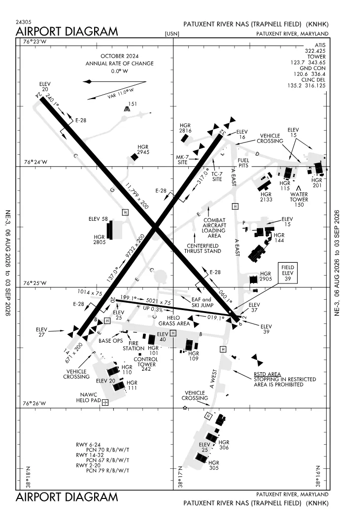 FAA airport diagramView full size ↓
 Nearby now
Loading…
Weather
METAR observed
Loading current weather…
TAF forecast
Loading forecast…
Sun & FAA night2026-09-18 · night begins 07:36 PM
| Event | Local (EDT) | UTC |
|---|---|---|
| Morning civil twilight Loggable night ends | 06:23 AM | 10:23Z |
| Sunrise | 06:50 AM | 10:50Z |
| Sunset | 07:09 PM | 23:09Z |
| Evening civil twilight Loggable night begins | 07:36 PM | 23:36Z |
Plan a flight from KNHK
Past 24 hours category · wind · ceiling · visibility trends
Loading station history…
Density altitude today projected curve · departure window · takeoff roll
Winds aloft NOAA forecast · 3,000 to 53,000 ft
Loading winds aloft…
Full reports: KNHK METAR decoded · KNHK TAF decoded
Advisories
NOTAMs · Loading NOTAMs…
Pilot reports · Loading PIREPs…
Airspace hazards · Checking SIGMETs and G-AIRMETs…
Temporary flight restrictions · Checking for TFRs…
Runways
RWY 14LEFT traffic
- Heading
- 136° mag · 126° true
- Dimensions
- 9,732 × 200 ft
- TPA
- 1,000 ft MSL (≈1,000 AGL) · standard
- Surface
- Asphalt
More details — RWY 14
- Threshold elev
- 27 ft
- Markings
- precision
- TDZ elevation
- 27 ft
- Arresting gear
- E28
Pattern side: FAA NASR · TPA standard 1,000 ft AGL (not charted) · layout: FAA runway-end coordinates
| Runway | Length | Your margin |
|---|---|---|
| 06/24 | 11,799 ft | |
| 14/32 | 9,732 ft | |
| 02/20 | 5,021 ft |
Prefer one flat page? Full runway details for KNHK → · New to pattern entries? The 45° entry, explained → · Teaching here? Print the KNHK kneeboard →
Comms & NavAids
Communication frequencies
Before taxi
“Patuxent”Taxi & takeoff
“Patuxent”Departure & arrival
“Patuxent”Also
ATC assigns the exact frequency (in your clearance or on handoff) — which one depends on your SID (departing) or STAR (arriving).
By procedure & sector (11 frequencies)
| Frequency | Used by |
|---|---|
| 243.0 | EMERG |
| 250.3 | APCH/P DEP/P (165-055 3000 FT & BLW) |
| 269.625 | APCH/S DEP/S (WHEN NHK APCH CLSD) |
| 281.8 | APCH/P DEP/P (165-055 ABV 3000 FT) |
| 314.0 | APCH/P DEP/P (056-164 ALL ALTS) |
| 316.125 | CD/P |
| 322.425 | ATIS |
| 336.4 | GND/P |
| 340.2 | LCL/S |
| 343.65 | LCL/P |
| 356.2 | PMSV METRO |
Source: FAA NASR (current 28-day cycle).
Instrument landing systems
RWY 06
| Runway | ILS |
|---|---|
| RWY 06 | ILS/DME · CAT I · LOC 108.7 (NHK) · GS 3.00° |
Source: FAA NASR (current 28-day cycle).
Nearby navigation aids
NHK 110.25 · OTT 113.70 · ADW 113.10
| NavAid | Type | Freq · ch | Range | Radial / Dist magnetic |
|---|---|---|---|---|
| NHK · Nas Patuxent River | TACAN | 110.25 · 39Y | — | r016° / 0.3 NM |
| OTT · Nottingham | TACAN | 113.70 · 84X | — | r158° / 29.7 NM |
| ADW · Andrews | VORTAC | 113.10 · 78X | Low | r155° / 37.9 NM |
Prefer one flat list? All KNHK frequencies →
Charts & procedures
Lowest minimums here: ILS with vertical guidance · VFR sectional →
Airport info
From the field
Do you run KNHK, or an FBO, flight school, or shop on it? Claim your listing to keep fuel, fees, hours, and services current.
Airport information
- ICAO / FAA LID
- KNHK / NHK
- Coordinates
- 38.2863, -76.4100
- Elevation
- 39 ft MSL
- Magnetic variation
- 10W
- Sectional chart
- WASHINGTON
- Airport use
- Private
- Control tower
- Yes
- Tower hours
- 24 HRS++ MON-SUN, OTHER TIMES BY NOTAM.
- Airspace
- Class D
- ARTCC
- WASHINGTON (ZDC)
- Flight service (FSS)
- LEESBURG · 1-800-WX-BRIEF
- NOTAM facility
- DCA
- Attendance
- ALL 1200-0400Z++.
- Beacon
- S-white-green (SS-SR)
- Segmented circle
- No
- Activated
- 1944/02
- Distance from city
- 0 N
Activity & hazards NASR
- Parachute jumping · 1600-SUNSET, WEEKDAYS. 0800-SUNSET, SAT SUN AND HOLIDAYS
- Parachute jumping
Night operations
- Airport lighting
- SEE RMK
- Rotating beacon
- S-white-green · SS-SR
Runway lighting aids — 06: ALSF1.
FAA night windows (civil twilight, loggable night §1.1, currency §61.57) are under Sun & FAA night in the Weather section.
Ownership & management 2 contacts
Remarks FAA · 23 notes
General
- JASU: (GTC-85) (NCPP-105) (NC-8) (NC-10).
- FUEL: 100LL, A, J5.
- FLUID: SP LHOX LOX.
- OIL: O-128-133-148-156 (MIL).
- TRAN ALERT: AVBL 1200-23000Z++ MON-FRI EXC HOL.
- REMARKS: OPR 1200-0400Z++ MON-FRI,1300-2300Z++ SAT-SUN, CLSD HOL. SEE FLIP AP/1 SUPPLEMENTARY ARPT RMK.
- RSTD: PPR-NO NOTAM TRML FAC AVBL. PPR REQUESTS SHOULD BE EMAILED TO PAXPPRS@US.NAVY.MIL TO CONFIRM RECEIPT OF PPRS CALL DSN 342-8923, C301-342-8923. ACFT MUST MAKE PRIOR ARNG AND RCV PPR FR HOST SQUADRON, OR NAS AIR OPERATONS. LTD RAMP SPACE, AND LTD TRAN SVC AVBL EXPECT DELAYS. TWY ALL EXP DLY DUE TO ACFT WT LIMITATIONS.
- CAUTION: STOPPING IN RSTD AREA ON TWY A, W TWY IS PROH. PORTIONS OF RWY, TWY AND ACFT RAMPS NOT VIS FR TWR. FIRST 1630 FT. RWY 32 MAY BE CLSD DALGT HR MON-SAT DUR VFR. BUILDINGS AND EQUIPMENT ARE LOCATED NEAR THE APPROACH END OF RWY 32. DEER AND BIRD HAZ.
- TFC PAT: VFR INITIAL AT 4 DME (RWY 32 AT 3 DME) 2000 FT, BREAK 1500 FT, DOWNWIND 1000 FT. REDUCED RWY SEPARATION STD IN EFF FOR LCL BASED USN/USMC ACFT.
- NS ABTMT: MIL ACFT MAINT AT LEAST 1500 FT BTN 3 NM AND 10 NM FR 210 DEG CW TO 240 DEG. NO PRACTICE APCH 0300Z++ TO 1200Z++ MON-FRI, SAT BEFORE 1500Z++, SUN BEFORE 1700Z++. TRAN ACFT PRACTICE APCH NOT TO INTERFERE BASIS.
- CSTMS/AG/IMG: LTD TO ACFT ON OFFICIAL BUSINESS AT PAX RIV WITH 72 HR PN. CTC AODO AT DSN 342-3836, C301-342-3836.
- MISC: WX FCST SVC AVBL 0900-0100Z++ MON-FRI. FOR FCST SVC ALL OT CTC FWC-N AT DSN 565-4555 OR C888-745-6899. WX OBSN AND PMSV MTR AVBL 1100-0400Z++ MON-FRI AND 1200-2300Z++ SAT-SUN.
- FOR CD WHEN NHK ATCT/APCH ARE CLSD CTC POTOMAC APCH AT 866-640-4124.
- MISC: FOR INFO REGARDING CIVIL AIR LANDING PERMITS (CALPS) CTC AFM AT 301-342-8923 OR EMAIL NASPATUXENTRIVERCALPS@US.NAVY.MIL.
- SERVICE: NO BASE TRANSPORTATION AVBL.
- MISC: NS NORFOLK, CHAMBERS FLD COORD ALL FLT PLANNING SVC. FLT PLANS SHOULD BE EMAILED TO W_CNI_NRFK_NSNORFOLK_N32_ATC_USERS@NAVY.MIL OR FAX TO DSN 565-9680, C757-445-9680. TO CONFIRM RECEIPT OF FLT PLANS CALL NS NORFOLK, CHAMBERS FLD FLT PLANNING SUPERVISOR AT DSN 232-3419/3429, C757-322-3419/3429.
- MISC: CLASS D AVAIL EXCLUDING THAT AIRSPACE WITHIN RESTRICTED AREAS R-4005 AND R-4007 WHEN ACTIVE. SEE FLIP AP/1 SUPPLEMENTARY ARPT REMARKS.
Lighting
- AVBL ONLY DURING HRS OF OPERATION.
- OLS.
- OLS.
- OLS.
- OLS.
Attendance
- CLSD HOLIDAYS.
Embed KNHK weather on your site free widget for schools, clubs & FBOs
Live METAR, flight category, and favored runway for KNHK — paste this into your website's HTML. It updates automatically and stays free.
More widgets — crosswind, E6B, density altitude — on the embed page.
Nearby airports
Loading nearby conditions…
Also nearby: MD50 Chesapeake Ranch (private) (5 NM) · 3MD6 West St Mary's (private) (6 NM) · 4MD0 Mears Creek Airfield (private) (6 NM) · 2W6 St Mary's County Regional (7 NM) · 65MD Willow Bee Farm Airfield (private) (9 NM)
About KNHK
Patuxent River NAS (Trapnell Field) (NHK · KNHK) is an airport in Patuxent River, MD, at 39 ft MSL. It has 3 runways, the longest 11,799 ft, with a control tower. This page shows live METAR/TAF weather, runway crosswinds, frequencies, navaids, and FAA charts for KNHK, refreshed from the Aviation Weather Center and FAA NASR.
Does KNHK have a control tower?
Yes. Patuxent River NAS (Trapnell Field) has an operating FAA control tower. See the Comms & NavAids section for tower and ground frequencies.
What is the longest runway at KNHK?
Patuxent River NAS (Trapnell Field) has 3 runways; the longest is 11,799 ft. See the Runways section for headings, surface, and lighting.
Where is KNHK?
Patuxent River NAS (Trapnell Field) is in Patuxent River, MD, at an elevation of 39 ft MSL. Coordinates: 38.2863, -76.4100.
More about KNHK
Weather is live from the Aviation Weather Center; airport facility data is from the FAA NASR (28-day cycle). For planning and education only; always verify against official sources. Open KNHK in a full tool: METAR/TAF decoder, crosswind calculator, sun & night times, or the density altitude calculator. Planning from here? Find the nearest airport with fuel or an approach, or check whether an IFR alternate is required.
Something here wrong or out of date? Report a data problem.